1921 Map of Satsop
USGS Topo · Published 1921About this map
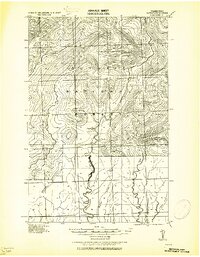
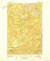
Olympic National Forest dominates the upper half of this 1921 tactical survey, revealing a landscape defined by its river systems and early industrial timber reach. The terrain rises toward Mt Baldy in the northwest, where the headwaters of the West Fork Humptulips River and Ziegler Creek begin their descent. Further east, the Wynoochee River carves a central path through the forest, passing the Wynoochee RS station before meeting tributaries like Save Creek. In the lower southeastern corner, the Simpson Logging R.R. appears along the West Fork Satsop River, marking the era's primary infrastructure for resource extraction. This sheet illustrates the transition from high mountain peaks to the drainage basins of the Wishkah River and Satsop River, providing a detailed look at the drainage patterns before modern development altered the region.
Find a feature on this map
16 named features on this map. Tap any name to fly to it.
Don’t see what you’re looking for? This feature index may not catch every label — zoom into the map to look around manually.
Map Details
Editions of this 1921 Satsop Map
This is the sole edition of this map. No revisions or reprints were ever made.
Other maps of this area

1921 · Quinault Lake
USGS Topo · 1:62,500

1938 · Mt Constance
USGS Topo · 1:125,000

1941 · Mobray
USGS Topo · 1:62,500
1943 · Humptulips
USGS Topo · 1:62,500

1943 · Nahwatzel Lake
USGS Topo · 1:62,500

1943 · Mobray
USGS Topo · 1:62,500
1947 · Mt. Steel
USGS Topo · 1:62,500
1947 · Mt Christie
USGS Topo · 1:62,500
1950 · Mt Christie
USGS Topo · 1:62,500
1950 · Mt. Steel
USGS Topo · 1:62,500