
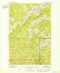
1950 Map of Mt. Steel
USGS Topo · Published 1950About this map
Darky Mine sits along the North Fork Skokomish River in this high-altitude survey of the interior Olympic Peninsula. The landscape is defined by the transition between Olympic National Park and Olympic National Forest, where high mountain peaks like Mt Steel and Mt Anderson overlook a network of backcountry infrastructure. The distribution of remote outposts, including Chalet, Hammer Cabin, and Lincoln Guard Sta, indicates a region managed for forestry and conservation rather than permanent settlement. Strategically placed trail infrastructure like Home Sweet Home Shelter and Diamond Meadow Shelter highlights the area's importance for early mid-century wilderness access. Glacial features such as Eel Glacier and Anderson Glacier are mapped in detail, feeding into major drainages like the Elwha River and Duckabush River that carve through the high ridgelines.
Find a feature on this map
100 named features on this map. Tap any name to fly to it.
Don’t see what you’re looking for? This feature index may not catch every label — zoom into the map to look around manually.
Map Details
Editions of this 1950 Mt. Steel Map
2 editions found
Other maps of this area

1921 · Satsop
USGS Topo · 1:62,500

1935 · Mount Olympus
USGS Topo · 1:62,500

1938 · Mt Constance
USGS Topo · 1:125,000

1942 · Mount Olympus
USGS Topo · 1:62,500

1943 · Potlatch
USGS Topo · 1:62,500

1944 · Mt. Angeles
USGS Topo · 1:62,500

1946 · Mt. Angeles
USGS Topo · 1:62,500

1946 · Tyler Peak
USGS Topo · 1:62,500

1947 · The Brothers
USGS Topo · 1:62,500

1947 · Mt. Steel
USGS Topo · 1:62,500