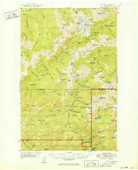
1950 Map of Mt. Steel
USGS Topo · Published 1950About this map
Enchanted Valley defines the heart of this 1950 survey, showcasing a landscape of glaciers and high peaks within the Olympic National Park. The map documents a network of backcountry infrastructure essential to mid-century wilderness travel, including the Enchanted Valley Trail and various shelters such as the Diamond Meadow Shelter and O'Neil Creek Shelter. At lower elevations, the North Fork Skokomish River flows toward the Staircase Guard Sta, a key administrative point for the Olympic National Forest.
Find a feature on this map
102 named features on this map. Tap any name to fly to it.
Don’t see what you’re looking for? This feature index may not catch every label — zoom into the map to look around manually.
Map Details
Editions of this 1950 Mt. Steel Map
2 editions found

Other maps of this area

1921 · Satsop
USGS Topo · 1:62,500

1935 · Mount Olympus
USGS Topo · 1:62,500

1938 · Mt Constance
USGS Topo · 1:125,000

1942 · Mount Olympus
USGS Topo · 1:62,500

1943 · Potlatch
USGS Topo · 1:62,500

1944 · Mt. Angeles
USGS Topo · 1:62,500

1946 · Mt. Angeles
USGS Topo · 1:62,500

1946 · Tyler Peak
USGS Topo · 1:62,500

1947 · The Brothers
USGS Topo · 1:62,500

1947 · Mt. Steel
USGS Topo · 1:62,500