1940s Maps of Hoquiam, Washington
Explore 1 historic maps of Hoquiam from the 1940s. These maps offer a rare glimpse into what life looked like during the 1940s — showing old roads, neighborhoods, homes, and landmarks that have changed or disappeared over time.
Whether you're researching your family's past, planning a metal detecting trip, or studying how Hoquiam's landscape evolved across the 1940s, these high-resolution maps are a powerful tool for exploring the history of this region.
- Focus on a specific era: All maps on this page are from the 1940s, giving you a focused view of this time period.
- See what’s changed: Compare century-old streets, trails, and buildings to today's modern landscape using overlays and satellite layers.
- Research with precision: Use these maps for genealogy, historical research, land use analysis, or educational projects.
- View, download, or print: Maps are fully viewable online in high resolution, and can be downloaded or printed for your own records.
Start exploring Hoquiam's history through authentic maps from the 1940s. This is your window into the past.
Hoquiam, WA maps
(1)- 1943 Map of Humptulips
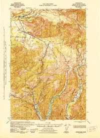 1943 Humptulips1943 Print · USGSGrays Harbor County timber and ranching lands come into focus during the early 1940s as the region transitioned toward modern infrastructure. Researchers can locate family homesteads like Brittain Ranch, industrial sites like the Polson Logging Company lines, and local hubs including Springfield Sch and New London.
End of results
Showing maps 1-1 of 1
Top cities near Hoquiam
- Aberdeen historical maps
- Ocean Shores historical maps
- Westport historical maps
- Cosmopolis historical maps
- Grayland historical maps
- Aberdeen Gardens historical maps
Top neighborhoods of Hoquiam
Frequently asked questions
- What are the different types of historical maps available for Hoquiam?
- What is the oldest map of Hoquiam?
- Where can I purchase historical maps of Hoquiam for my home or office?
- Where can I download high-res historical maps of Hoquiam?
- Are there historical topographic maps available for Hoquiam?
- Is there historical aerial imagery available for Hoquiam?
- Where are historical maps of Hoquiam sourced from?