1980s Maps of Taholah, Washington
Explore 2 historic maps of Taholah from the 1980s. These maps offer a rare glimpse into what life looked like during the 1980s — showing old roads, neighborhoods, homes, and landmarks that have changed or disappeared over time.
Whether you're researching your family's past, planning a metal detecting trip, or studying how Taholah's landscape evolved across the 1980s, these high-resolution maps are a powerful tool for exploring the history of this region.
- Focus on a specific era: All maps on this page are from the 1980s, giving you a focused view of this time period.
- See what’s changed: Compare century-old streets, trails, and buildings to today's modern landscape using overlays and satellite layers.
- Research with precision: Use these maps for genealogy, historical research, land use analysis, or educational projects.
- View, download, or print: Maps are fully viewable online in high resolution, and can be downloaded or printed for your own records.
Start exploring Taholah's history through authentic maps from the 1980s. This is your window into the past.
Taholah, WA maps
(2)- 1980 Map of Copalis Beach, 1988 Print
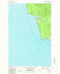
 1980 Copalis Beach1988 Print · USGSThe Grays Harbor coast in the early eighties shows a landscape defined by the Quinault Indian Reservation and seaside rail history. Researchers can trace the Burlington Northern route through Moclips, Aloha, and Copalis Crossing.
 - 1982 Map of Taholah
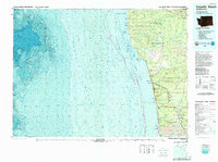
 1982 Taholah1982 Print · USGSCoastal Washington in the early eighties shows the settlement of Taholah at the mouth of the Quinault River. Researchers can trace the path of an Old Railroad Grade and locate geological curiosities like the Garfield Gas Mound and Gas Vent.2 unique versions available
End of results
Showing maps 1-2 of 2
Top cities near Taholah
Frequently asked questions
- What are the different types of historical maps available for Taholah?
- What is the oldest map of Taholah?
- Where can I purchase historical maps of Taholah for my home or office?
- Where can I download high-res historical maps of Taholah?
- Are there historical topographic maps available for Taholah?
- Is there historical aerial imagery available for Taholah?
- Where are historical maps of Taholah sourced from?