1900s (20th Century) Maps of North Bend, Washington
Explore 10 historic maps of North Bend from the 1900s (20th Century). These maps offer a rare glimpse into what life looked like during the 1900s — showing old roads, neighborhoods, homes, and landmarks that have changed or disappeared over time.
Whether you're researching your family's past, planning a metal detecting trip, or studying how North Bend's landscape evolved across the 1900s, these high-resolution maps are a powerful tool for exploring the history of this region.
- Focus on a specific era: All maps on this page are from the 1900s, giving you a focused view of this time period.
- See what’s changed: Compare century-old streets, trails, and buildings to today's modern landscape using overlays and satellite layers.
- Research with precision: Use these maps for genealogy, historical research, land use analysis, or educational projects.
- View, download, or print: Maps are fully viewable online in high resolution, and can be downloaded or printed for your own records.
Start exploring North Bend's history through authentic maps from the 1900s. This is your window into the past.
North Bend, WA maps
(10)- 1913 Map of Cedar Lake
 1913 Cedar Lake1913 Print · USGSThe foothills and peaks of the Cascades appear here just before World War I as industry pushed into the wilderness. Trace early timber and rail history through Kerriston, Selleck, and the Cedar Falls Power Plant.5 unique versions available
 - 1921 Map of Sultan
 1921 Sultan1921 Print · USGSThe Snoqualmie and Skykomish river valleys are defined by timber and rail in the 1920s. Researchers can trace early industry through the Apex Mines, Coke Ovens, and rural schools like Mountain View School.4 unique versions available
 - 1923 Map of Sultan
 1923 Sultan1923 Print · USGSThe Skykomish and Snoqualmie river valleys thrive in the early twenties as centers of timber and rail. Genealogists can trace family roots through rural sites like Forest Glade School or follow the Lumber RR lines to the Apex Mines.4 unique versions available
 - 1953 Map of Snoqualmie, 1955 Print
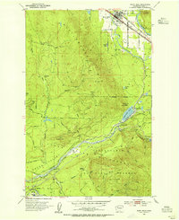
 1953 Snoqualmie1955 Print · USGSThe Snoqualmie Valley in the early fifties shows a bustling hub of timber and rail operations centered around the river forks. Researchers can trace the massive Lumber Mill and Powerhouse near Snoqualmie Falls or find local landmarks like Mt Si High Sch.5 unique versions available
 - 1953 Map of North Bend, 1955 Print
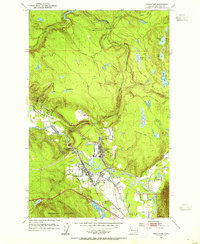
 1953 North Bend1955 Print · USGSThe Snoqualmie Valley and the surrounding Cascades thrive with rail and timber activity in the early fifties. Local historians can trace the footprint of the Milwaukee Road, the Selleck community, and vanished locations like Hemlock (Site).4 unique versions available
 - 1957 Map of Wenatchee, 1973 Print
 1957 Wenatchee1973 Print · USGSThe northern Cascades and Columbia River valley appear here in the mid-fifties, showing the region's critical rail and transit corridors. Researchers can trace the routes of the Great Northern RR and Milwaukee Road through settlements like Skykomish, Baring, and Dryden.2 unique versions available
 - 1975 Map of Snoqualmie Pass, 1977 Print
 1975 Snoqualmie Pass1977 Print · USGSThe central Cascades are shown here in the mid-seventies, just as the regional balance between industrial timber, rail transport, and recreation was shifting. Genealogists and hikers can trace old rail stops like Lester and Nagrom, or follow the Pacific Crest National Scenic Trail past Keechelus Lake.
 - 1975 Map of Skykomish River, 1977 Print
 1975 Skykomish River1977 Print · USGSThe Cascades meet the river valleys in the mid-seventies, showing the vital rail corridors and mountain towns along the Skykomish River. Researchers can trace the path of the Pacific Crest National Scenic Trail and locate historic sites like State Reformatory Farm No 2 and the Old Cascade Tunnel.2 unique versions available
 - 1993 Map of Snoqualmie
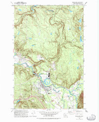 1993 Snoqualmie1993 Print · USGSSnoqualmie and North Bend are documented in the early nineties, showing a landscape defined by timber milling and river power. Researchers can trace the legacy of the Lumber Mill, the Snoqualmie Falls Powerhouse, and the remnants of the Old Railroad Grade.
 - 1993 Map of North Bend
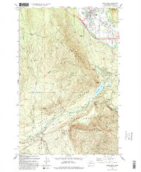 1993 North Bend1993 Print · USGSNorth Bend and the Snoqualmie Valley are shown here in the early nineties, framed by the industrial and protective boundaries of the Cascades. Researchers can trace the footprints of old timber and mill towns like Kerriston, Barneston, and Selleck.2 unique versions available
End of results
Showing maps 1-10 of 10
Top cities near North Bend
- Kent historical maps
- Sammamish historical maps
- Issaquah historical maps
- Snoqualmie historical maps
- Hobart historical maps
- Black Diamond historical maps
See more
Top neighborhoods of North Bend
- Forster Woods historical maps
- Arrive Appartments historical maps
- Si View historical maps
- The Meadows historical maps
Frequently asked questions
- What are the different types of historical maps available for North Bend?
- What is the oldest map of North Bend?
- Where can I purchase historical maps of North Bend for my home or office?
- Where can I download high-res historical maps of North Bend?
- Are there historical topographic maps available for North Bend?
- Is there historical aerial imagery available for North Bend?
- Where are historical maps of North Bend sourced from?