1950s Maps of North Bend, Washington
Explore 3 historic maps of North Bend from the 1950s. These maps offer a rare glimpse into what life looked like during the 1950s — showing old roads, neighborhoods, homes, and landmarks that have changed or disappeared over time.
Whether you're researching your family's past, planning a metal detecting trip, or studying how North Bend's landscape evolved across the 1950s, these high-resolution maps are a powerful tool for exploring the history of this region.
- Focus on a specific era: All maps on this page are from the 1950s, giving you a focused view of this time period.
- See what’s changed: Compare century-old streets, trails, and buildings to today's modern landscape using overlays and satellite layers.
- Research with precision: Use these maps for genealogy, historical research, land use analysis, or educational projects.
- View, download, or print: Maps are fully viewable online in high resolution, and can be downloaded or printed for your own records.
Start exploring North Bend's history through authentic maps from the 1950s. This is your window into the past.
North Bend, WA maps
(3)- 1953 Map of Snoqualmie, 1955 Print
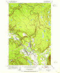 1953 Snoqualmie1955 Print · USGSThe Snoqualmie Valley in the early fifties shows a bustling hub of timber and rail operations centered around the river forks. Researchers can trace the massive Lumber Mill and Powerhouse near Snoqualmie Falls or find local landmarks like Mt Si High Sch.5 unique versions available
 - 1953 Map of North Bend, 1955 Print
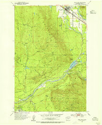 1953 North Bend1955 Print · USGSThe Snoqualmie Valley and the surrounding Cascades thrive with rail and timber activity in the early fifties. Local historians can trace the footprint of the Milwaukee Road, the Selleck community, and vanished locations like Hemlock (Site).4 unique versions available
 - 1957 Map of Wenatchee, 1973 Print
 1957 Wenatchee1973 Print · USGSThe northern Cascades and Columbia River valley appear here in the mid-fifties, showing the region's critical rail and transit corridors. Researchers can trace the routes of the Great Northern RR and Milwaukee Road through settlements like Skykomish, Baring, and Dryden.2 unique versions available
End of results
Showing maps 1-3 of 3
Top cities near North Bend
- Kent historical maps
- Sammamish historical maps
- Issaquah historical maps
- Snoqualmie historical maps
- Hobart historical maps
- Black Diamond historical maps
See more
Top neighborhoods of North Bend
- Forster Woods historical maps
- Arrive Appartments historical maps
- Si View historical maps
- The Meadows historical maps
Frequently asked questions
- What are the different types of historical maps available for North Bend?
- What is the oldest map of North Bend?
- Where can I purchase historical maps of North Bend for my home or office?
- Where can I download high-res historical maps of North Bend?
- Are there historical topographic maps available for North Bend?
- Is there historical aerial imagery available for North Bend?
- Where are historical maps of North Bend sourced from?