1900s (20th Century) Maps of Sammamish, Washington
Explore 13 historic maps of Sammamish from the 1900s (20th Century). These maps offer a rare glimpse into what life looked like during the 1900s — showing old roads, neighborhoods, homes, and landmarks that have changed or disappeared over time.
Whether you're researching your family's past, planning a metal detecting trip, or studying how Sammamish's landscape evolved across the 1900s, these high-resolution maps are a powerful tool for exploring the history of this region.
- Focus on a specific era: All maps on this page are from the 1900s, giving you a focused view of this time period.
- See what’s changed: Compare century-old streets, trails, and buildings to today's modern landscape using overlays and satellite layers.
- Research with precision: Use these maps for genealogy, historical research, land use analysis, or educational projects.
- View, download, or print: Maps are fully viewable online in high resolution, and can be downloaded or printed for your own records.
Start exploring Sammamish's history through authentic maps from the 1900s. This is your window into the past.
Sammamish, WA maps
(13)- 1921 Map of Sultan
 1921 Sultan1921 Print · USGSThe Snoqualmie and Skykomish river valleys are defined by timber and rail in the 1920s. Researchers can trace early industry through the Apex Mines, Coke Ovens, and rural schools like Mountain View School.4 unique versions available
 - 1923 Map of Sultan
 1923 Sultan1923 Print · USGSThe Skykomish and Snoqualmie river valleys thrive in the early twenties as centers of timber and rail. Genealogists can trace family roots through rural sites like Forest Glade School or follow the Lumber RR lines to the Apex Mines.4 unique versions available
 - 1950 Map of Redmond, 1956 Print
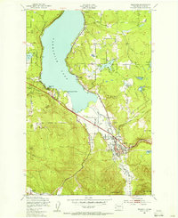
 1950 Redmond1956 Print · USGSRedmond and the northern shores of Lake Sammamish are shown here in the early fifties before the rapid expansion of the Seattle suburbs. Researchers can trace the Northern Pacific line or locate small settlements like Adelaide, White, and Kenilworth.4 unique versions available
 - 1950 Map of Issaquah, 1956 Print
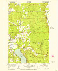
 1950 Issaquah1956 Print · USGSIssaquah and the eastern shores of Sammamish Lake are captured in the early 1950s before the arrival of modern interstate highways. Trace old transit lines like the Northern Pacific railroad and find local landmarks such as the Issaquah Airport and Monohon.4 unique versions available
 - 1953 Map of Fall City, 1955 Print
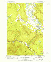 1953 Fall City1955 Print · USGSKing County's river valleys and timbered ridges are captured here during the 1950s, showing the intersection of rail and river life. Genealogists and historians can trace the foundations of Fall City and Preston, or locate the Reynolds Mine and Fall City Cemetery.5 unique versions available
 - 1957 Map of Wenatchee, 1973 Print
 1957 Wenatchee1973 Print · USGSThe northern Cascades and Columbia River valley appear here in the mid-fifties, showing the region's critical rail and transit corridors. Researchers can trace the routes of the Great Northern RR and Milwaukee Road through settlements like Skykomish, Baring, and Dryden.2 unique versions available
 - 1958 Map of Seattle, 1966 Print
 1958 Seattle1966 Print · USGSThe Puget Sound region in the mid-fifties showcases a balance of urban growth and Olympic wilderness. Trace the industrial waterfronts of Tacoma, old naval facilities like Keyport Naval Res, and mountain peaks like Mount Constance.3 unique versions available
 - 1962 Map of Seattle
 1962 Seattle1962 Print · USGSThe Puget Sound region and Olympic Peninsula are shown at a peak of mid-century growth. Genealogists and historians can trace rail lines like the Pacific Coast RR or locate landmarks such as Fort Lawton and the Bothell Power Station.
 - 1975 Map of Skykomish River, 1977 Print
 1975 Skykomish River1977 Print · USGSThe Cascades meet the river valleys in the mid-seventies, showing the vital rail corridors and mountain towns along the Skykomish River. Researchers can trace the path of the Pacific Crest National Scenic Trail and locate historic sites like State Reformatory Farm No 2 and the Old Cascade Tunnel.2 unique versions available
 - 1975 Map of Seattle, 1977 Print
 1975 Seattle1977 Print · USGSThe Puget Sound region in the mid-seventies shows a landscape of rapid suburban growth and vital maritime industry. Researchers can trace the development of Eastside hubs like Bellevue or examine the rail and naval infrastructure of Bremerton and Paine Field.
 - 1983 Map of Bellevue South
 1983 Bellevue South1983 Print · USGSThe Eastside area between Lake Washington and Lake Sammamish was rapidly developing into a major suburban hub in the early eighties. Researchers can trace neighborhood growth through Beaux Arts Village, locate family records at Sunset Hills Mem Park (Cem), or follow the old Burlington Northern line.
 - 1992 Map of Seattle, 1993 Print
 1992 Seattle1993 Print · USGSThe Seattle metropolitan area and Puget Sound are shown here in the early nineties during a period of rapid suburban and technological growth. Researchers can trace the development of Mercer Island, locate the Bangor Naval Submarine Base, and study the industrial layout of Boeing Field.2 unique versions available
 - 1993 Map of Fall City
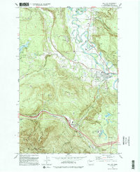 1993 Fall City1993 Print · USGSKing County's river valleys and foothills are captured here in the early nineties as suburban development began to blend with rural landscapes. Genealogists and historians can locate the Fall City Cemetery and trace the paths of the Old RR Grade and Tiger Mountain Trail.
End of results
Showing maps 1-13 of 13
Top cities near Sammamish
- Seattle historical maps
- Bellevue historical maps
- Kent historical maps
- Renton historical maps
- Kirkland historical maps
- Redmond historical maps
See more
Top neighborhoods of Sammamish
- Klahanie historical maps
- Trossachs historical maps
- Inglewood historical maps
- Trossachs historical maps
- Autumn Wind historical maps
- Hunter's Ridge historical maps
See more
Frequently asked questions
- What are the different types of historical maps available for Sammamish?
- What is the oldest map of Sammamish?
- Where can I purchase historical maps of Sammamish for my home or office?
- Where can I download high-res historical maps of Sammamish?
- Are there historical topographic maps available for Sammamish?
- Is there historical aerial imagery available for Sammamish?
- Where are historical maps of Sammamish sourced from?