1940s Maps of Kitsap County, Washington
Explore 9 historic maps of Kitsap County from the 1940s. These maps offer a rare glimpse into what life looked like during the 1940s — showing old roads, neighborhoods, homes, and landmarks that have changed or disappeared over time.
Whether you're researching your family's past, planning a metal detecting trip, or studying how Kitsap County's landscape evolved across the 1940s, these high-resolution maps are a powerful tool for exploring the history of this region.
- Focus on a specific era: All maps on this page are from the 1940s, giving you a focused view of this time period.
- See what’s changed: Compare century-old streets, trails, and buildings to today's modern landscape using overlays and satellite layers.
- Research with precision: Use these maps for genealogy, historical research, land use analysis, or educational projects.
- View, download, or print: Maps are fully viewable online in high resolution, and can be downloaded or printed for your own records.
Start exploring Kitsap County's history through authentic maps from the 1940s. This is your window into the past.
Kitsap County, WA maps
(9)- 1940 Map of Port Gamble
 1940 Port Gamble1940 Print · USGSThe Kitsap Peninsula and Hood Canal are seen here in the final years before the bridge era, when a complex network of ferries was the lifeblood of the sound. Genealogists and local historians can trace the early footprints of Port Gamble, Hansville, and the Port Madison Indian Reservation.
 - 1940 Map of Point Misery
 1940 Point Misery1940 Print · USGSCoastal life along the Hood Canal and Dabob Bay is caught in detail just before the mid-century, from timber operations to maritime crossings. Genealogists and historians can trace the Brinnon Seabeck Ferry, identify the Barney White Ranch, and locate the Seabeck Sch.
 - 1942 Map of Edmonds, 1944 Print
 1942 Edmonds1944 Print · USGSCoastal Snohomish County and Whidbey Island are captured in the early 1940s during a period of maritime and rail expansion. Researchers can trace historic ferry lines, the Great Northern railroad, and local landmarks like Alderwood Manor and Firlands Sanitarium.
 - 1942 Map of Gig Harbor, 1954 Print
 1942 Gig Harbor1954 Print · USGSThe Kitsap Peninsula and surrounding islands are mapped here during the early 1940s, highlighting a maritime world of inlets and ferries. Trace old family sites and rural landmarks like Elgin Sch, Lisabeula, and the many landings along Henderson Bay.
 - 1943 Map of Gig Harbor
 1943 Gig Harbor1943 Print · USGSThe Puget Sound shoreline and its peninsulas are captured here in the 1940s as a maritime network of small landings and inland schools. Genealogists can trace family footprints at Sunny Slope Sch, Lisabeula, and the many homesteads near Artondale.
 - 1947 Map of The Brothers, 1957 Print
 1947 The Brothers1957 Print · USGSThe Olympic Peninsula wilderness meets the shoreline in the late 1940s, showing the rugged interior before modern expansion. Researchers can locate the John Ahl Sch near Eldon or trace mountain trails to the Webb Lookout and The Brothers.3 unique versions available
 - 1949 Map of Shilshole Bay, 1954 Print
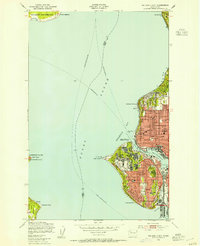 1949 Shilshole Bay1954 Print · USGSSeattle's northwestern waterfront is captured in the mid-century as neighborhoods like Ballard and Loyal Heights expand near the industrial shore. Trace the rail lines of the Great Northern and find historic sites like Fort Lawton and West Point Light.4 unique versions available
 - 1949 Map of Duwamish Head, 1956 Print
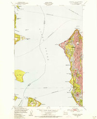 1949 Duwamish Head1956 Print · USGSThe Seattle waterfront and Puget Sound islands are captured here in the years following World War II, when ferries were the lifeblood of the sound. Genealogists and local historians can trace the development of West Seattle, Fauntleroy, and Vashon Heights alongside landmarks like Lafayette Sch and the Laurel Beach Sanatorium.3 unique versions available
 - 1949 Map of Vashon, 1956 Print
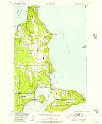 1949 Vashon1956 Print · USGSVashon and Maury Islands are captured here in the late 1940s, showing a landscape defined by waterfront settlements and maritime life. Genealogists can trace family locations in small communities like Burton, Ellisport, and Sylvan Beach, or find local landmarks such as Vashon Sch and the KOMO Radio Towers.4 unique versions available
End of results
Showing maps 1-9 of 9
Top cities of Kitsap County
- Bremerton historical maps
- Bainbridge Island historical maps
- Silverdale historical maps
- Port Orchard historical maps
- Poulsbo historical maps
- Parkwood historical maps
See more
Frequently asked questions
- What are the different types of historical maps available for Kitsap County?
- What is the oldest map of Kitsap County?
- Where can I purchase historical maps of Kitsap County for my home or office?
- Where can I download high-res historical maps of Kitsap County?
- Are there historical topographic maps available for Kitsap County?
- Is there historical aerial imagery available for Kitsap County?
- Where are historical maps of Kitsap County sourced from?