1990s Maps of Kitsap County, Washington
Explore 13 historic maps of Kitsap County from the 1990s. These maps offer a rare glimpse into what life looked like during the 1990s — showing old roads, neighborhoods, homes, and landmarks that have changed or disappeared over time.
Whether you're researching your family's past, planning a metal detecting trip, or studying how Kitsap County's landscape evolved across the 1990s, these high-resolution maps are a powerful tool for exploring the history of this region.
- Focus on a specific era: All maps on this page are from the 1990s, giving you a focused view of this time period.
- See what’s changed: Compare century-old streets, trails, and buildings to today's modern landscape using overlays and satellite layers.
- Research with precision: Use these maps for genealogy, historical research, land use analysis, or educational projects.
- View, download, or print: Maps are fully viewable online in high resolution, and can be downloaded or printed for your own records.
Start exploring Kitsap County's history through authentic maps from the 1990s. This is your window into the past.
Kitsap County, WA maps
(13)- 1991 Map of Tacoma
 1991 Tacoma1991 Print · USGSThe South Sound and Tacoma waterfront appear here in the early nineties, showing a landscape defined by deep-water inlets and massive federal installations. Researchers can trace the development of Lakewood Center or locate the historic rail lines of the Burlington Northern Railroad and Union Pacific Railroad.
 - 1992 Map of Seattle, 1993 Print
 1992 Seattle1993 Print · USGSThe Seattle metropolitan area and Puget Sound are shown here in the early nineties during a period of rapid suburban and technological growth. Researchers can trace the development of Mercer Island, locate the Bangor Naval Submarine Base, and study the industrial layout of Boeing Field.2 unique versions available
 - 1997 Map of Wildcat Lake, 2003 Print
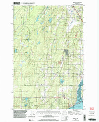
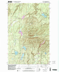 1997 Wildcat Lake2003 Print · USGSThe Kitsap Peninsula highlands appear in the late twentieth century as a landscape of mountain ridges and secluded lake communities. Researchers can trace the development of Camp Union, the sprawling Union River Reservoir, and family landmarks like the Barney White Ranch.
 - 1997 Map of Edmonds West, 2003 Print
 1997 Edmonds West2003 Print · USGSPuget Sound’s busy maritime corridor is captured here in the late nineties, documenting the evolving shoreline from the Kitsap Peninsula to Edmonds. Maritime researchers can trace ferry lanes, locate a Sunken Wreck near Apple Cove Point, and see industrial sites like the oil tanks at Point Wells.
 - 1997 Map of Hansville, 2003 Print
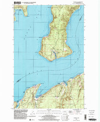
 1997 Hansville2003 Print · USGSThe northern tip of the Kitsap Peninsula is captured here in the late twentieth century, showing a landscape defined by maritime landmarks and quiet coastal settlements. Genealogists and local historians can trace the roads around Hansville, locate the Cem, and see prominent points like Point No Point and Foulweather Bluff.
 - 1997 Map of Suquamish, 2003 Print
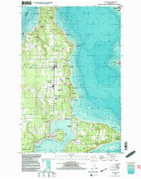
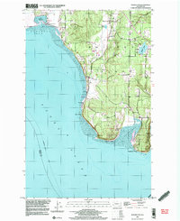
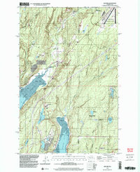
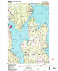 1997 Suquamish2003 Print · USGSCoastal Kitsap and Bainbridge Island are shown here in the late twentieth century as local maritime and military hubs evolved. Researchers can find many community markers, from the Bainbridge Grange and Poulsbo Cemetery to the Agate Pass Bridge.
 - 1997 Map of Vashon, 2003 Print
 1997 Vashon2003 Print · USGSVashon and Maury Islands are shown at the close of the twentieth century, detailing the dense coastal settlements of the southern Sound. Genealogists and local historians can trace family properties near Burton, Ellisport, and the Vashon Municipal Airport.
 - 1997 Map of Seabeck, 2003 Print
 1997 Seabeck2003 Print · USGSThe shorelines of the Kitsap and Toandos Peninsulas are captured here in the late 1990s as the regional maritime economy and naval presence shaped the land. Researchers can trace local landmarks like Camp Parsons, the settlement at Warrenville, and the waters of Big Beef Harbor.
 - 1997 Map of Maxwelton, 2003 Print
 1997 Maxwelton2003 Print · USGSSouthern Whidbey Island in the late nineties shows a landscape of tidal lagoons and established coastal communities. You can trace local landmarks like Sunlight Beach, the wetlands of Deer Lagoon, and the prominent landmarks of Scatchet Head and Possession Point.
 - 1997 Map of Port Gamble, 2003 Print
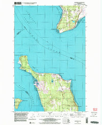
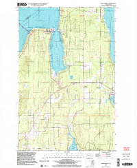 1997 Port Gamble2003 Print · USGSKitsap Peninsula's northern tip in the late nineties shows the enduring presence of the Port Gamble Indian Reservation and maritime commerce. Trace family roots and local industry near Little Boston, the sawmill at Port Gamble, and the Kingston Grange.
 - 1999 Map of Brinnon, 2001 Print
 1999 Brinnon2001 Print · USGSThe western shores of Hood Canal come into sharp focus in the late nineties, where the mountains meet the sea. Local historians can trace the development of Brinnon and Brinnon Flats alongside the Dosewallips River and the rural Brinnon School.
 - 1999 Map of Burley, 2003 Print
 1999 Burley2003 Print · USGSThe Key Peninsula and the Kitsap-Pierce county line are shown here in the late nineties, centered on the communities of Burley and Purdy. Local historians can trace family-named landmarks and rural infrastructure from Bethel Ch to the Port Orchard Airport.
 - 1999 Map of Belfair, 2003 Print
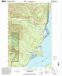
 1999 Belfair2003 Print · USGSThe Mason County shoreline near the turn of the millennium shows a landscape shaped by the Hood Canal and North Bay. Researchers can trace local infrastructure from the Navy Railroad to the Sand Hill Sch and the Lake Koeneman Wildlife Area.
End of results
Showing maps 1-13 of 13
Top cities of Kitsap County
- Bremerton historical maps
- Bainbridge Island historical maps
- Silverdale historical maps
- Port Orchard historical maps
- Poulsbo historical maps
- Parkwood historical maps
See more
Frequently asked questions
- What are the different types of historical maps available for Kitsap County?
- What is the oldest map of Kitsap County?
- Where can I purchase historical maps of Kitsap County for my home or office?
- Where can I download high-res historical maps of Kitsap County?
- Are there historical topographic maps available for Kitsap County?
- Is there historical aerial imagery available for Kitsap County?
- Where are historical maps of Kitsap County sourced from?