1900s (20th Century) Maps of Liberty, Washington
Explore 5 historic maps of Liberty from the 1900s (20th Century). These maps offer a rare glimpse into what life looked like during the 1900s — showing old roads, neighborhoods, homes, and landmarks that have changed or disappeared over time.
Whether you're researching your family's past, planning a metal detecting trip, or studying how Liberty's landscape evolved across the 1900s, these high-resolution maps are a powerful tool for exploring the history of this region.
- Focus on a specific era: All maps on this page are from the 1900s, giving you a focused view of this time period.
- See what’s changed: Compare century-old streets, trails, and buildings to today's modern landscape using overlays and satellite layers.
- Research with precision: Use these maps for genealogy, historical research, land use analysis, or educational projects.
- View, download, or print: Maps are fully viewable online in high resolution, and can be downloaded or printed for your own records.
Start exploring Liberty's history through authentic maps from the 1900s. This is your window into the past.
Liberty, WA maps
(5)- 1902 Map of Mount Stuart, 1908 Print
 1902 Mount Stuart1908 Print · USGSThe Kittitas Valley and Wenatchee Mountains are shown here during the height of the early twentieth-century rail and mining era. Researchers can trace the industrial landscape through the Roslyn Branch and mountain camps like Liberty and Blewett.5 unique versions available
 - 1957 Map of Wenatchee, 1973 Print
 1957 Wenatchee1973 Print · USGSThe northern Cascades and Columbia River valley appear here in the mid-fifties, showing the region's critical rail and transit corridors. Researchers can trace the routes of the Great Northern RR and Milwaukee Road through settlements like Skykomish, Baring, and Dryden.2 unique versions available
 - 1961 Map of Liberty, 1963 Print
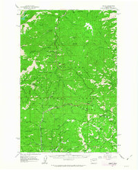 1961 Liberty1963 Print · USGSThe high Cascades of Chelan and Kittitas counties are captured here in the early sixties, showing the transition from mining era to modern recreation. Trace the former Blewett townsite, the historic mining camp of Liberty, and the Mineral Springs Resort.2 unique versions available
 - 1975 Map of Wenatchee, 1977 Print
 1975 Wenatchee1977 Print · USGSCentral Washington in the mid-seventies shows a landscape of deep mountain valleys and bustling river towns. Trace the industrial and agricultural backbone of the region along the Yakima River and Columbia River, from the mining history of Roslyn to the rail hubs at Cle Elum and Appleyard.
 - 1989 Map of Liberty
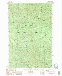 1989 Liberty1989 Print · USGSThe high country of Kittitas County is seen here in the late eighties, just as recreational and mining interests converged in the Wenatchee Mountains. Researchers can locate specific prospect sites and strip mines near the settlement of Liberty or trace routes through Blewett Pass.2 unique versions available
End of results
Showing maps 1-5 of 5
Top cities near Liberty
Frequently asked questions
- What are the different types of historical maps available for Liberty?
- What is the oldest map of Liberty?
- Where can I purchase historical maps of Liberty for my home or office?
- Where can I download high-res historical maps of Liberty?
- Are there historical topographic maps available for Liberty?
- Is there historical aerial imagery available for Liberty?
- Where are historical maps of Liberty sourced from?