1900s (20th Century) Maps of Long Lake, Washington
Explore 6 historic maps of Long Lake from the 1900s (20th Century). These maps offer a rare glimpse into what life looked like during the 1900s — showing old roads, neighborhoods, homes, and landmarks that have changed or disappeared over time.
Whether you're researching your family's past, planning a metal detecting trip, or studying how Long Lake's landscape evolved across the 1900s, these high-resolution maps are a powerful tool for exploring the history of this region.
- Focus on a specific era: All maps on this page are from the 1900s, giving you a focused view of this time period.
- See what’s changed: Compare century-old streets, trails, and buildings to today's modern landscape using overlays and satellite layers.
- Research with precision: Use these maps for genealogy, historical research, land use analysis, or educational projects.
- View, download, or print: Maps are fully viewable online in high resolution, and can be downloaded or printed for your own records.
Start exploring Long Lake's history through authentic maps from the 1900s. This is your window into the past.
Long Lake, WA maps
(6)- 1944 Map of Wellpinit
 1944 Wellpinit1944 Print · USGSThe Spokane Indian Reservation and the winding Spokane River define this 1940s landscape during an era of logging and early hydroelectric power. Genealogists and historians can trace the foundations of local life at Wellpinit, the Deer Park Logging Camp, and the State Fish Hatchery.2 unique versions available
 - 1953 Map of Wellpinit, 1955 Print
 1953 Wellpinit1955 Print · USGSThe Spokane Indian Reservation and the rugged Stevens County hills come to life in the early fifties. Genealogists and historians can locate St Joseph Ch, the Wellpinit settlement, and local landmarks like Little Chamokane Falls.3 unique versions available
 - 1955 Map of Spokane, 1965 Print
 1955 Spokane1965 Print · USGSInland Empire life in the fifties and sixties centers on the growth of Spokane and the heavy mining industry of northern Idaho. Trace mid-century landmarks like Fairchild Air Force Base, the Bunker Hill Mine, and early campuses such as Gonzaga University.2 unique versions available
 - 1958 Map of Spokane
 1958 Spokane1958 Print · USGSThe Inland Empire is shown at a mid-century peak of industrial and military activity, from the rail hubs of Spokane to the deep silver mines of northern Idaho. Researchers can trace the sprawling rail lines of the Union Pacific RR or locate landmarks like Fairchild Air Force Base and the Bunker Hill Smelter & Mine.
 - 1973 Map of Long Lake, 1977 Print
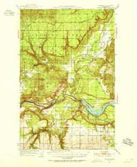
 1973 Long Lake1977 Print · USGSThe Spokane River corridor in the early 1970s reveals a landscape shaped by hydroelectric power and rural industry at the meeting of three counties. Researchers can trace the shoreline of Long Lake and locate local landmarks such as Long Lake Dam, the settlement of Crescent, and Chamokane Falls.
 - 1987 Map of Spokane
 1987 Spokane1987 Print · USGSGreater Spokane and its surrounding prairies are captured in the late 1980s as the region solidified its role as a regional hub. Researchers can trace family sites near Medical Lake, military life at Fairchild Air Force Base, and rural settlements like Peone and Chattaroy.
End of results
Showing maps 1-6 of 6
Top cities near Long Lake
Frequently asked questions
- What are the different types of historical maps available for Long Lake?
- What is the oldest map of Long Lake?
- Where can I purchase historical maps of Long Lake for my home or office?
- Where can I download high-res historical maps of Long Lake?
- Are there historical topographic maps available for Long Lake?
- Is there historical aerial imagery available for Long Lake?
- Where are historical maps of Long Lake sourced from?