
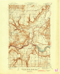
1944 Map of Wellpinit
USGS Topo · Published 1944About this map
The Spokane Indian Reservation occupies much of this landscape, centered on the community of Wellpinit during the early 1940s. The terrain is defined by the winding course of the Spokane River, which forms the southern boundary and widens into Long Lake. The map details a transition between wilderness and industry, showing the Deer Park Logging Camp in the northern heights near Round Mtn and the State Fish Hatchery along the river. Institutional and community life is anchored by locations like Reservation Sch and St Joseph Ch. Hydroelectric development and water management are evident at Little Falls and Little Chamokane Falls, while a network of rural routes including Drum Road and Kelley Road connect remote settlements like Ford.
Find a feature on this map
27 named features on this map. Tap any name to fly to it.
Don’t see what you’re looking for? This feature index may not catch every label — zoom into the map to look around manually.
Map Details
Editions of this 1944 Wellpinit Map
2 editions found
Other maps of this area

1927 · Chewelah
USGS Topo · 1:125,000

1930 · Chewelah
USGS Topo · 1:125,000

1943 · Medical Lake
USGS Topo · 1:62,500

1944 · Clayton
USGS Topo · 1:62,500

1945 · Reardan
USGS Topo · 1:62,500

1948 · Hunters
USGS Topo · 1:62,500

1948 · Turtle Lake
USGS Topo · 1:62,500

1950 · Turtle Lake
USGS Topo · 1:62,500

1950 · Hunters
USGS Topo · 1:62,500

1950 · Clayton
USGS Topo · 1:62,500