
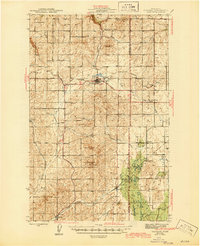
1948 Map of Turtle Lake
USGS Topo · Published 1969About this map
Spokane Indian Reservation lands dominate the northeastern quadrant of this landscape, where the confluence of the Spokane River and Franklin D Roosevelt Lake shapes the central topography. In the late 1940s, this region was a working landscape of remote mountain peaks and isolated social centers, such as the North Star Grange and the Community Club. The map reveals a transition from the agricultural flats of Egypt to the mining-rich slopes of Spokane Mtn and Pitney Butte. Notable for its record of early mid-century resource extraction, the survey identifies several significant operations including the Germania Consolidated Mine and the Spokane Molybdenum Mine. Local life is anchored by landmarks like the Church of Our Lady of Lourdes and the St Augustine Sch, while recreational spots like Blue Creek Camp on the shores of Turtle Lake highlight the area's emerging role in the national recreational network.
Find a feature on this map
48 named features on this map. Tap any name to fly to it.
Don’t see what you’re looking for? This feature index may not catch every label — zoom into the map to look around manually.
Map Details
Editions of this 1948 Turtle Lake Map
This is the sole edition of this map. No revisions or reprints were ever made.
Other maps of this area

1927 · Chewelah
USGS Topo · 1:125,000

1930 · Chewelah
USGS Topo · 1:125,000

1944 · Wellpinit
USGS Topo · 1:62,500
1945 · Reardan
USGS Topo · 1:62,500

1948 · Hunters
USGS Topo · 1:62,500

1948 · Wilmont Creek
USGS Topo · 1:62,500
1948 · Lincoln
USGS Topo · 1:62,500

1950 · Lincoln
USGS Topo · 1:62,500
1950 · Turtle Lake
USGS Topo · 1:62,500

1950 · Wilmont Creek
USGS Topo · 1:62,500