
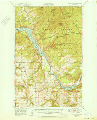
1950 Map of Turtle Lake
USGS Topo · Published 1950About this map
The Spokane Indian Reservation and the rising waters of the Franklin D Roosevelt Lake National Recreational Area define this mid-century portrait of Stevens County. Established shortly after the completion of the Grand Coulee Dam, the map shows the flooded canyon of the Spokane River and its impact on the surrounding landscape. On the higher ground of the Spokane Indian Reservation, mining remains a critical industry, evidenced by the Germania Mine, Germania Consolidated Mine, and the Spokane Molybdenum Mine. Local social and spiritual centers are well-documented, including the Church of Our Lady of Lourdes, St Augustine Sch, and rural hubs like the North Star Grange. This survey captures the transition from a traditional river-valley economy to one shaped by the massive Columbia River Basin Project and its new recreational infrastructure.
Find a feature on this map
62 named features on this map. Tap any name to fly to it.
Don’t see what you’re looking for? This feature index may not catch every label — zoom into the map to look around manually.
Map Details
Editions of this 1950 Turtle Lake Map
2 editions found
Other maps of this area

1927 · Chewelah
USGS Topo · 1:125,000

1930 · Chewelah
USGS Topo · 1:125,000

1944 · Wellpinit
USGS Topo · 1:62,500

1945 · Reardan
USGS Topo · 1:62,500

1948 · Hunters
USGS Topo · 1:62,500

1948 · Wilmont Creek
USGS Topo · 1:62,500

1948 · Lincoln
USGS Topo · 1:62,500

1948 · Turtle Lake
USGS Topo · 1:62,500

1950 · Lincoln
USGS Topo · 1:62,500

1950 · Wilmont Creek
USGS Topo · 1:62,500