1980s Maps of Conconully, Washington
Explore 3 historic maps of Conconully from the 1980s. These maps offer a rare glimpse into what life looked like during the 1980s — showing old roads, neighborhoods, homes, and landmarks that have changed or disappeared over time.
Whether you're researching your family's past, planning a metal detecting trip, or studying how Conconully's landscape evolved across the 1980s, these high-resolution maps are a powerful tool for exploring the history of this region.
- Focus on a specific era: All maps on this page are from the 1980s, giving you a focused view of this time period.
- See what’s changed: Compare century-old streets, trails, and buildings to today's modern landscape using overlays and satellite layers.
- Research with precision: Use these maps for genealogy, historical research, land use analysis, or educational projects.
- View, download, or print: Maps are fully viewable online in high resolution, and can be downloaded or printed for your own records.
Start exploring Conconully's history through authentic maps from the 1980s. This is your window into the past.
Conconully, WA maps
(3)- 1981 Map of Conconully East
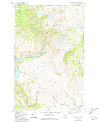 1981 Conconully East1981 Print · USGSThe mountain valley of Conconully is captured here in the early 1980s, centered on the lakes and forests of the Okanogan. Researchers can locate the Peacock Mine, find family names at Conconully Cem and Ruby Cem, or trace the old Silver Hill Road.
 - 1984 Map of Oroville
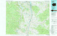 1984 Oroville1984 Print · USGSThe Okanogan highlands at the Canadian border reveal a landscape of deep river valleys and historic mining claims in the early 1980s. Genealogists and researchers can trace old settlements like Nighthawk and Loomis or locate the American Girl Mine.
 - 1989 Map of Conconully West
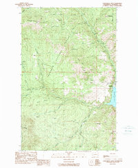 1989 Conconully West1989 Print · USGSOkanogan County's mining and ranching heritage is on display in this late twentieth-century survey of the terrain surrounding Conconully. Researchers can trace the legacy of local extraction at the Sunny Peak Mine and Wheeler Mine, or locate family-named landmarks like Reed Ranch.
End of results
Showing maps 1-3 of 3
Top cities near Conconully
Frequently asked questions
- What are the different types of historical maps available for Conconully?
- What is the oldest map of Conconully?
- Where can I purchase historical maps of Conconully for my home or office?
- Where can I download high-res historical maps of Conconully?
- Are there historical topographic maps available for Conconully?
- Is there historical aerial imagery available for Conconully?
- Where are historical maps of Conconully sourced from?