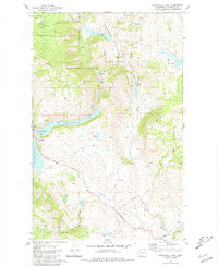
1981 Map of Conconully East
USGS Topo · Published 1981About this map
Conconully serves as the focal point for this mountain landscape, positioned between the waters of Conconully Lake and the Conconully Reservoir. The town's historical roots are visible in local landmarks like the Conconully Cem and the Ruby Cem to the south, while the Peacock Mine on the slopes of Happy Hill points to the area's extraction history. Much of the surrounding terrain is defined by conservation and resource management, spanning the Okanogan National Forest and the Sinlahekin State Wildlife Recreation Area. High peaks such as Funk Mountain and Dunn Mountain frame the valley, which is drained by Salmon Creek and Sinlahekin Creek. Public recreation is centered around Conconully State Park, providing access to the reservoirs and numerous alpine ponds including Fish Lake and Sugarloaf Lake.
Find a feature on this map
42 named features on this map. Tap any name to fly to it.
Don’t see what you’re looking for? This feature index may not catch every label — zoom into the map to look around manually.
Map Details
Editions of this 1981 Conconully East Map
This is the sole edition of this map. No revisions or reprints were ever made.
Other maps of this area

1905 · Okanogan
USGS Topo · 1:125,000

1906 · Chopaka
USGS Topo · 1:125,000

1954 · Okanogan
USGS Topo · 1:250,000

1956 · Loup Loup
USGS Topo · 1:62,500

1956 · Tiffany Mountain
USGS Topo · 1:62,500

1957 · Okanogan
USGS Topo · 1:62,500

1957 · Conconully
USGS Topo · 1:62,500

1958 · Okanogan
USGS Topo · 1:250,000
1980 · Omak
USGS Topo · 1:24,000
1980 · Aeneas Lake
USGS Topo · 1:24,000