
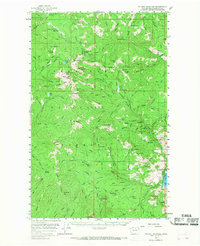
1956 Map of Tiffany Mountain
USGS Topo · Published 1959About this map
Okanogan National Forest dominates this mid-century survey, revealing a landscape defined by its mining history and remote mountain passes. The town of Conconully sits at the base of the mountains, adjacent to Conconully State Park, serving as a gateway to the high country. Resource extraction is evident through numerous named sites like the Bernhardt Mine and Johnny Boy Mine, while agricultural outposts like Meyer Ranch and Reed Ranch occupy the lower elevations. High-altitude landmarks such as Tiffany Mtn and Clark Peak are connected by a network of trails and primitive roads, including the Sinlahekin Road. The presence of Woodpile Cabin and several other remote cabins highlights the area's utility for forestry and trapping during this era. This study documents a specific period in the Okanogan, where recreational campgrounds like Oriole Campground began to intermingle with active mining claims.
Find a feature on this map
104 named features on this map. Tap any name to fly to it.
Don’t see what you’re looking for? This feature index may not catch every label — zoom into the map to look around manually.
Map Details
Editions of this 1956 Tiffany Mountain Map
2 editions found
Other maps of this area

1899 · Methow
USGS Topo · 1:125,000

1901 · Methow
USGS Topo · 1:125,000

1905 · Okanogan
USGS Topo · 1:125,000

1906 · Chopaka
USGS Topo · 1:125,000

1954 · Okanogan
USGS Topo · 1:250,000

1955 · Concrete
USGS Topo · 1:250,000

1956 · Loup Loup
USGS Topo · 1:62,500

1956 · Loomis
USGS Topo · 1:62,500

1956 · Horseshoe Basin
USGS Topo · 1:62,500

1957 · Okanogan
USGS Topo · 1:62,500