
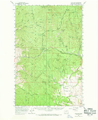
1956 Map of Loup Loup
USGS Topo · Published 1959About this map
Okanogan National Forest dominates this mid-century landscape, characterized by a complex network of high ridges and narrow creek valleys. The central Loup Loup Highway serves as the primary artery through the mountains, crossing the Loup Loup Summit and providing access to the Loup Loup Recreation Area. For genealogists and local historians, the map identifies specific family-named sites such as Kercheval Ranch and Stout Ranch near the settlement of Olema.
Find a feature on this map
57 named features on this map. Tap any name to fly to it.
Don’t see what you’re looking for? This feature index may not catch every label — zoom into the map to look around manually.
Map Details
Editions of this 1956 Loup Loup Map
2 editions found
Other maps of this area

1899 · Methow
USGS Topo · 1:125,000

1901 · Methow
USGS Topo · 1:125,000

1905 · Okanogan
USGS Topo · 1:125,000

1906 · Chopaka
USGS Topo · 1:125,000

1954 · Okanogan
USGS Topo · 1:250,000

1955 · Concrete
USGS Topo · 1:250,000

1956 · Tiffany Mountain
USGS Topo · 1:62,500

1957 · Okanogan
USGS Topo · 1:62,500

1957 · Bridgeport
USGS Topo · 1:62,500

1957 · Conconully
USGS Topo · 1:62,500