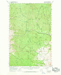
1956 Map of Loup Loup
USGS Topo · Published 1969About this map
Olema and the surrounding Chiliwist Valley anchor this mid-century survey of the Okanogan highlands, depicting a landscape defined by seasonal camps and livestock ranching. The map illustrates a network of resource extraction and high-country recreation, most notably the Red Shirt Mine and the Loup Loup Recreation Area. The rugged terrain of the Okanogan National Forest is mapped in detail, revealing the complex drainage systems of Beaver Creek and Salmon Creek that carve through ridges like Ritchie Ridge and Middle Ridge.
Find a feature on this map
57 named features on this map. Tap any name to fly to it.
Don’t see what you’re looking for? This feature index may not catch every label — zoom into the map to look around manually.
Map Details
Editions of this 1956 Loup Loup Map
2 editions found
Other maps of this area

1899 · Methow
USGS Topo · 1:125,000

1901 · Methow
USGS Topo · 1:125,000

1905 · Okanogan
USGS Topo · 1:125,000

1906 · Chopaka
USGS Topo · 1:125,000

1954 · Okanogan
USGS Topo · 1:250,000

1955 · Concrete
USGS Topo · 1:250,000

1956 · Loup Loup
USGS Topo · 1:62,500

1956 · Tiffany Mountain
USGS Topo · 1:62,500

1957 · Okanogan
USGS Topo · 1:62,500

1957 · Bridgeport
USGS Topo · 1:62,500