1980s Maps of Ilwaco, Washington
Explore 3 historic maps of Ilwaco from the 1980s. These maps offer a rare glimpse into what life looked like during the 1980s — showing old roads, neighborhoods, homes, and landmarks that have changed or disappeared over time.
Whether you're researching your family's past, planning a metal detecting trip, or studying how Ilwaco's landscape evolved across the 1980s, these high-resolution maps are a powerful tool for exploring the history of this region.
- Focus on a specific era: All maps on this page are from the 1980s, giving you a focused view of this time period.
- See what’s changed: Compare century-old streets, trails, and buildings to today's modern landscape using overlays and satellite layers.
- Research with precision: Use these maps for genealogy, historical research, land use analysis, or educational projects.
- View, download, or print: Maps are fully viewable online in high resolution, and can be downloaded or printed for your own records.
Start exploring Ilwaco's history through authentic maps from the 1980s. This is your window into the past.
Ilwaco, WA maps
(3)- 1980 Map of Ilwaco, 1989 Print
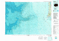 1980 Ilwaco1989 Print · USGSThe Washington-Oregon borderlands come into focus during the 1980s, revealing the coastal communities of the North Beach Peninsula and the mouth of the Columbia. Researchers can trace historical sites like Fort Canby State Park, locate the North Head Lighthouse, and explore the shoreline from Ocean Park to Ilwaco.
 - 1981 Map of Astoria, 1982 Print
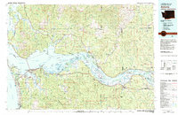 1981 Astoria1982 Print · USGSThe Oregon and Washington borderlands meet at the Columbia River estuary in the early eighties, a time of active timber transport and maritime trade. Researchers can trace the river's many islands, the grounds of Fort Stevens, and riverside towns like Cathlamet and Westport.3 unique versions available
 - 1984 Map of Chinook, 1985 Print
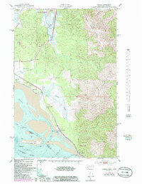 1984 Chinook1985 Print · USGSThe Washington coast met the Columbia River in the mid-1980s as a land of tide-influenced marshes and family-run ranches. Researchers can trace land holdings at Kyle Ranch and Beeker Ranch or locate the shoreline lights at Sand Island.
End of results
Showing maps 1-3 of 3
Top cities near Ilwaco
- Astoria historical maps
- Warrenton historical maps
- Ocean Park historical maps
- Long Beach historical maps
Frequently asked questions
- What are the different types of historical maps available for Ilwaco?
- What is the oldest map of Ilwaco?
- Where can I purchase historical maps of Ilwaco for my home or office?
- Where can I download high-res historical maps of Ilwaco?
- Are there historical topographic maps available for Ilwaco?
- Is there historical aerial imagery available for Ilwaco?
- Where are historical maps of Ilwaco sourced from?