1940s Maps of Ilwaco, Washington
Explore 4 historic maps of Ilwaco from the 1940s. These maps offer a rare glimpse into what life looked like during the 1940s — showing old roads, neighborhoods, homes, and landmarks that have changed or disappeared over time.
Whether you're researching your family's past, planning a metal detecting trip, or studying how Ilwaco's landscape evolved across the 1940s, these high-resolution maps are a powerful tool for exploring the history of this region.
- Focus on a specific era: All maps on this page are from the 1940s, giving you a focused view of this time period.
- See what’s changed: Compare century-old streets, trails, and buildings to today's modern landscape using overlays and satellite layers.
- Research with precision: Use these maps for genealogy, historical research, land use analysis, or educational projects.
- View, download, or print: Maps are fully viewable online in high resolution, and can be downloaded or printed for your own records.
Start exploring Ilwaco's history through authentic maps from the 1940s. This is your window into the past.
Ilwaco, WA maps
(4)- 1943 Map of Fort Columbia
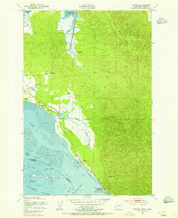
 1943 Fort Columbia1943 Print · USGSThe coastal defense and river economy of Pacific County are captured here during the wartime era. Genealogists and historians can locate numerous family-named landmarks like Gile Ranch or Kyle Ranch alongside the Naselle State Salmon Hatchery and Fort Columbia.
 - 1943 Map of Copalis Beach
 1943 Copalis Beach1943 Print · USGSThe Washington coast in the 1940s is detailed here from the Olympic Peninsula to the Columbia River. Trace old beach settlements like Moclips and Copalis Beach alongside landmarks like the Willapa Bay Lighthouse.
 - 1949 Map of Chinook, 1954 Print
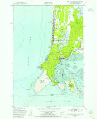
 1949 Chinook1954 Print · USGSThe mouth of the Columbia River and the rugged Pacific County coastline are captured here in the mid-twentieth century. Genealogists and local historians can trace family landholdings like Goulter Ranch and Beeker Ranch alongside landmarks like Stringtown and Fort Columbia Military Reservation.4 unique versions available
 - 1949 Map of Cape Disappointment, 1955 Print
 1949 Cape Disappointment1955 Print · USGSThe Washington coast at the mouth of the Columbia River comes alive in this mid-century survey of the Long Beach Peninsula. Genealogists and local historians can trace family properties like Christorf Ranch, visit the Lone Fir Cem, or locate the historic Fort Canby military grounds.4 unique versions available
End of results
Showing maps 1-4 of 4
Top cities near Ilwaco
- Astoria historical maps
- Warrenton historical maps
- Ocean Park historical maps
- Long Beach historical maps
Frequently asked questions
- What are the different types of historical maps available for Ilwaco?
- What is the oldest map of Ilwaco?
- Where can I purchase historical maps of Ilwaco for my home or office?
- Where can I download high-res historical maps of Ilwaco?
- Are there historical topographic maps available for Ilwaco?
- Is there historical aerial imagery available for Ilwaco?
- Where are historical maps of Ilwaco sourced from?