
1943 Map of Fort Columbia
USGS Topo · Published 1943About this map
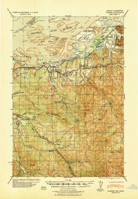
Fort Columbia Military Reservation and the strategic heights of Scarboro Hill dominate the southwestern corner of this coastal landscape, overlooking the critical entrance to the Columbia River and Baker Bay. During the early 1940s, this region was a vital intersection of defense and industry. The coastline is dotted with maritime and commercial landmarks, including a Fish Cannery near Hungry Harbor and the U S Quarantine Station at Knappton. Inland, the economy is driven by natural resources, evidenced by a Logging Camp along the Naselle River and the Naselle State Salmon Hatchery. Family history is deeply rooted in the numerous named ranches such as Gile Ranch, Oman Ranch, and Simaka Ranch that line the river valleys. The transportation network of the era is captured through a mix of plank roads, rural routes, and the ferry crossing at Megler, which provided essential connectivity before modern bridges spanned the wide river mouth.
Find a feature on this map
68 named features on this map. Tap any name to fly to it.
Don’t see what you’re looking for? This feature index may not catch every label — zoom into the map to look around manually.
Map Details
Editions of this 1943 Fort Columbia Map
This is the sole edition of this map. No revisions or reprints were ever made.
Other maps of this area

1919 · Astoria
USGS Topo · 1:62,500

1938 · Cape Disappointment
USGS Topo · 1:62,500

1938 · Cape Shoalwater
USGS Topo · 1:62,500

1938 · Fort Columbia
USGS Topo · 1:62,500

1938 · South Bend
USGS Topo · 1:62,500

1939 · Astoria
USGS Topo · 1:62,500
1940 · Svensen
USGS Topo · 1:62,500

1940 · Brookfield
USGS Topo · 1:62,500

1940 · South Bend
USGS Topo · 1:62,500

1943 · Copalis Beach
USGS Topo · 1:250,000