
1940 Map of Brookfield
USGS Topo · Published 1940About this map
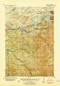
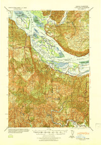
Brookfield and Altoona anchor the northern bank of the Columbia River in this tactical survey prepared by the Corps of Engineers. The map illustrates a landscape defined by the river-based economy of the 1940s, featuring industrial sites like the Pillar Rock Cannery and Miller Sands Fish Barn. Moving inland from Grays Bay, the terrain rises into the coastal hills where timber extraction is evident through the Deep River Logging Co Camp and Old Camp Brix Logging Co. Small rural communities are connected by a network of truck trails and roads such as Naselle Loop Road, with local life centered around the Naselle Rosburg Church and several small schoolhouses including Maple Grove School and Eden School. The inclusion of several family-named ranch sites, such as Shannon Ranch and Maki Ranch, provides valuable data for genealogists tracing local land ownership during this era.
Find a feature on this map
104 named features on this map. Tap any name to fly to it.
Don’t see what you’re looking for? This feature index may not catch every label — zoom into the map to look around manually.
Map Details
Editions of this 1940 Brookfield Map
This is the sole edition of this map. No revisions or reprints were ever made.
Other maps of this area

1919 · Astoria
USGS Topo · 1:62,500

1938 · Fort Columbia
USGS Topo · 1:62,500

1938 · South Bend
USGS Topo · 1:62,500

1939 · Astoria
USGS Topo · 1:62,500
1940 · Svensen
USGS Topo · 1:62,500

1940 · South Bend
USGS Topo · 1:62,500

1941 · Walville
USGS Topo · 1:62,500

1941 · Skamokawa
USGS Topo · 1:62,500
1941 · Cathlamet
USGS Topo · 1:62,500

1943 · Fort Columbia
USGS Topo · 1:62,500