
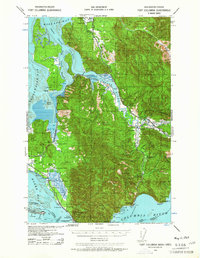
1938 Map of Fort Columbia
USGS Topo · Published 1957About this map
Fort Columbia Military Reservation stands as a sentinel at the mouth of the Columbia River, anchoring a coastal landscape defined by the tidal fluctuations of Willapa Bay and the river’s massive estuary. This 1938 survey captures a community deeply rooted in the maritime and timber economies of Southwest Washington, where numerous family holdings like the S Ring Ranch, J P Church Ranch, and M D Goulter Ranch dot the valley floors and ridges. The Naselle River winds through the interior toward Naselle, supporting local infrastructure like the Naselle State Salmon Hatchery. Along the southern shoreline, industrial and federal sites such as the U S Quarantine Station, a Fish Cannery, and the Chinook Jetty illustrate the navigational and commercial importance of Baker Bay and the surrounding waters.
Find a feature on this map
79 named features on this map. Tap any name to fly to it.
Don’t see what you’re looking for? This feature index may not catch every label — zoom into the map to look around manually.
Map Details
Editions of this 1938 Fort Columbia Map
2 editions found
Other maps of this area

1919 · Astoria
USGS Topo · 1:62,500

1938 · Cape Disappointment
USGS Topo · 1:62,500

1938 · Cape Shoalwater
USGS Topo · 1:62,500

1938 · South Bend
USGS Topo · 1:62,500

1939 · Astoria
USGS Topo · 1:62,500

1940 · Svensen
USGS Topo · 1:62,500

1940 · Brookfield
USGS Topo · 1:62,500

1940 · South Bend
USGS Topo · 1:62,500

1943 · Fort Columbia
USGS Topo · 1:62,500

1943 · Copalis Beach
USGS Topo · 1:250,000