
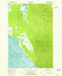
1938 Map of Cape Disappointment
USGS Topo · Published 1938About this map
The Long Beach Peninsula in the late 1930s is a narrow corridor of coastal commerce and maritime defense, anchored by Fort Canby and the U S Military Reservation at its southern tip. This survey highlights an economy built on the water, featuring several commercial structures like the Eagle Oyster Co Dock and Wiegat Bros Oyster Dock along the Nahcotta Channel. Inland from the Pacific Ocean coastline, a dense network of freshwater lakes including Loomis Lake and Black Lake separates the primary settlements of Nahcotta, Long Beach, and Ilwaco. For researchers, the map provides precise locations for family landmarks such as the Loomis Ranch and Ivy Rasmuson Ranch, alongside local curiosities like the Wreckage Park Zoo and the Moby Dick Hotel. This era represents a time when the Ocean Park Highway served as the primary artery for the peninsula’s growing seaside communities.
Find a feature on this map
99 named features on this map. Tap any name to fly to it.
Don’t see what you’re looking for? This feature index may not catch every label — zoom into the map to look around manually.
Map Details
Editions of this 1938 Cape Disappointment Map
This is the sole edition of this map. No revisions or reprints were ever made.
Other maps of this area

1919 · Astoria
USGS Topo · 1:62,500

1938 · Cape Shoalwater
USGS Topo · 1:62,500

1938 · Fort Columbia
USGS Topo · 1:62,500

1938 · South Bend
USGS Topo · 1:62,500

1939 · Astoria
USGS Topo · 1:62,500

1940 · South Bend
USGS Topo · 1:62,500

1943 · Fort Columbia
USGS Topo · 1:62,500

1943 · Copalis Beach
USGS Topo · 1:250,000
1949 · Chinook
USGS Topo · 1:24,000
1949 · Ocean Park
USGS Topo · 1:24,000