
1939 Map of Astoria
USGS Topo · Published 1939About this map
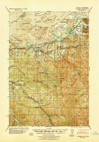
The Columbia River estuary dominates this landscape, where the U. S. Military Reservation at Point Adams stands guard over the Pacific entrance. This era is defined by a dense network of water-based industry and transportation, featuring the Spokane Portland and Seattle Railway winding through Astoria past the Astoria Box Co and the CRPA Cold Storage Plant. To the east, the Submarine and Destroyer Base at Tongue Point highlights the strategic importance of the harbor. Moving inland along the Lewis and Clark River, the map reveals a rural community supported by institutions like the Netel Grange and small local schools including Battle Creek Sch and Cooperage Sch. The Clatsop Spit and Clatsop Plains show a mix of natural features like Cullaby Lake alongside developing recreation at the Astoria Country Club, illustrating the transition from a maritime frontier to a regional hub.
Find a feature on this map
81 named features on this map. Tap any name to fly to it.
Don’t see what you’re looking for? This feature index may not catch every label — zoom into the map to look around manually.
Map Details
Editions of this 1939 Astoria Map
This is the sole edition of this map. No revisions or reprints were ever made.
Other maps of this area

1919 · Astoria
USGS Topo · 1:62,500

1938 · Cape Disappointment
USGS Topo · 1:62,500

1938 · Fort Columbia
USGS Topo · 1:62,500

1939 · Saddle Mountain
USGS Topo · 1:62,500
1940 · Svensen
USGS Topo · 1:62,500

1940 · Brookfield
USGS Topo · 1:62,500

1940 · Cape Falcon
USGS Topo · 1:62,500

1943 · Fort Columbia
USGS Topo · 1:62,500

1943 · Saddle Mtn.
USGS Topo · 1:62,500

1943 · Copalis Beach
USGS Topo · 1:250,000