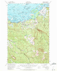
1940 Map of Svensen
USGS Topo · Published 1940About this map
Cathlamet Bay and the lower reach of the Columbia River dominate this 1940 tactical survey, revealing a landscape of braided channels and riverine islands. Along the southern shore, the Spokane Portland and Seattle Ry and the Columbia Highway connect small riverside settlements like Svensen, Brownsmead, and Ivy Station. This era shows a community infrastructure built around education and natural resources, featuring the Union High Sch, Svensen Sch, and specialized facilities like the Klaskanine Fish Hatchery Sch near the North Fork Klaskanine River.
Find a feature on this map
78 named features on this map. Tap any name to fly to it.
Don’t see what you’re looking for? This feature index may not catch every label — zoom into the map to look around manually.
Map Details
Editions of this 1940 Svensen Map
This is the sole edition of this map. No revisions or reprints were ever made.