1940s Maps of Pacific, Washington
Explore 6 historic maps of Pacific from the 1940s. These maps offer a rare glimpse into what life looked like during the 1940s — showing old roads, neighborhoods, homes, and landmarks that have changed or disappeared over time.
Whether you're researching your family's past, planning a metal detecting trip, or studying how Pacific's landscape evolved across the 1940s, these high-resolution maps are a powerful tool for exploring the history of this region.
- Focus on a specific era: All maps on this page are from the 1940s, giving you a focused view of this time period.
- See what’s changed: Compare century-old streets, trails, and buildings to today's modern landscape using overlays and satellite layers.
- Research with precision: Use these maps for genealogy, historical research, land use analysis, or educational projects.
- View, download, or print: Maps are fully viewable online in high resolution, and can be downloaded or printed for your own records.
Start exploring Pacific's history through authentic maps from the 1940s. This is your window into the past.
Pacific, WA maps
(6)- 1941 Map of Tacoma South, 1958 Print
 1941 Tacoma South1958 Print · USGSThe Puyallup Valley and southern Tacoma outskirts appear here in the early 1940s, just as the region’s rail and military infrastructure reached peak complexity. Genealogists can trace early homesteads and pioneer landmarks like the Site of Old Camp Montgomery and the Mary Mount Military Academy.
 - 1942 Map of Lake Tapps, 1962 Print
 1942 Lake Tapps1962 Print · USGSThe foothills of the Cascades meet the Puyallup Valley in the 1940s, showing a landscape defined by logging and coal extraction. Genealogists can locate family names on markers like Spar Pole Hill or trace rural social hubs like the Sunrise Grange Hall.3 unique versions available
 - 1944 Map of Lake Tapps
 1944 Lake Tapps1944 Print · USGSPierce County during the early 1940s reveals a landscape of industrial river towns and hill-country resource extraction. Genealogists can trace family roots through the Kelly Lake Sch, Coal Mines near Wilkeson, and the Sunrise Grange Hall.3 unique versions available
 - 1944 Map of Tacoma South
 1944 Tacoma South1944 Print · USGSPierce County during the war years shows a landscape of growing towns and deep-rooted history between the river valleys and the prairie. Genealogists and historians can trace family roots through numerous country schools like Kirby Sch or locate 19th-century frontier outposts like the Site of Old Camp Montgomery (1854).
 - 1949 Map of Poverty Bay, 1956 Print
 1949 Poverty Bay1956 Print · USGSThe Puget Sound shoreline and the emerging Federal Way corridor are captured here during the late 1940s. Genealogists and local historians can trace early neighborhood footprints from Woodmont Beach to Madrona Heights and locate landmarks like Evergreen Airfield and Steel Lake Ch.
 - 1949 Map of Auburn, 1956 Print
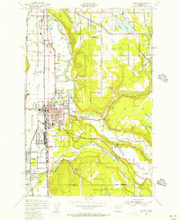 1949 Auburn1956 Print · USGSThe Green River valley at the close of the 1940s shows a landscape of growing towns and heavy rail infrastructure. Trace the early layout of Auburn and its General Depot, alongside landmarks like White Lake and the Muckleshoot Indian Reservation.5 unique versions available
End of results
Showing maps 1-6 of 6
Top cities near Pacific
- Seattle historical maps
- Tacoma historical maps
- Kent historical maps
- Renton historical maps
- Federal Way historical maps
- Auburn historical maps
See more
Frequently asked questions
- What are the different types of historical maps available for Pacific?
- What is the oldest map of Pacific?
- Where can I purchase historical maps of Pacific for my home or office?
- Where can I download high-res historical maps of Pacific?
- Are there historical topographic maps available for Pacific?
- Is there historical aerial imagery available for Pacific?
- Where are historical maps of Pacific sourced from?