Old Maps of North Bonneville, Washington for Genealogy
Trace your family roots with 25 historic maps of North Bonneville. These high-res maps reveal old neighborhoods, homesites, landmarks, and streets — helping you uncover where your ancestors lived and how the area evolved over time.
- Explore historic neighborhoods: Identify where your relatives may have lived in the 1800s or 1900s.
- Compare maps over time: Trace the changes in streets, buildings, and landmarks for multi-generational research.
- Perfect for genealogy & ancestry research: Used by family historians and researchers to map out lineage and migration.
These maps are an incredible resource for exploring your personal connection to North Bonneville's past.
North Bonneville, WA maps
(25)- 1926 Map of Hood River, 1955 Print
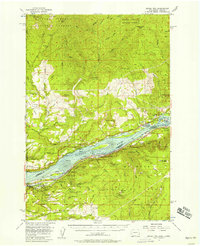
 1926 Hood River1955 Print · USGSThe Columbia River Gorge in the mid-twenties shows a landscape defined by competing railroads and early trans-river engineering. Trace the rail lines between Stevenson and Hood River, or locate historic sites like Hemlock Sch and the Bridge of the Gods.
 - 1929 Map of Hood River
 1929 Hood River1929 Print · USGSThe Columbia River Gorge and Hood River Valley are captured here in the late twenties during a period of significant infrastructure growth. Researchers can trace the early rail networks, find remote forest outposts like Race Track Ranger Sta, and locate vanished landmarks such as the Government Sprs Hotel.3 unique versions available
 - 1948 Map of Vancouver, 1957 Print
 1948 Vancouver1957 Print · USGSPost-war growth transforms the river valleys of the Pacific Northwest as the timber and rail economy thrives. Trace family roots in Tillamook or Oregon City, and locate vanished landmarks like the spit at Bayocean or the Skamania Mine.
 - 1950 Map of Vancouver
 1950 Vancouver1950 Print · USGSCoastal Oregon and the lower Columbia River valley are captured in detail just after the war. Researchers can trace historic rail routes like the Southern Pacific or locate early settlements such as Vernonia, Gaston, and the Grand Ronde Indian Reservation.
 - 1950 Map of Vancouver, 1951 Print
 1950 Vancouver1951 Print · USGSThe Pacific Northwest urban corridor meets the rugged coast in the years following the war, showing the expansion of Portland and Vancouver. Genealogists and historians can trace the reach of the Southern Pacific RR and locate coastal communities like Tillamook, Seaside, and Tolovana Park.
 - 1953 Map of The Dalles, 1965 Print
 1953 The Dalles1965 Print · USGSThe Columbia River Gorge at mid-century shows a region being transformed by massive hydroelectric dams and a growing highway network. Researchers can trace the development of The Dalles Dam, locate the Maryhill Museum, and find old rail stops in Rufus, Wishram, and Arlington.3 unique versions available
 - 1954 Map of Bridal Veil, 1958 Print
 1954 Bridal Veil1958 Print · USGSThe Columbia River Gorge in the mid-1950s was a bustling corridor of rail lines and early highways. Genealogists and historians can trace the foundations of riverside communities like Bridal Veil and Dodson or locate industrial sites like the Skamania Mine.4 unique versions available
 - 1956 Map of The Dalles
 1956 The Dalles1956 Print · USGSThe Columbia River Gorge and the high Cascades are captured in the mid-1950s, showing a vital corridor of rail and road. Researchers can trace the original path of The Old Oregon Trail or locate historical landmarks like the Maryhill Museum and Mount Hood.
 - 1957 Map of The Dalles
 1957 The Dalles1957 Print · USGSThe Columbia River Gorge and the high plateaus of the mid-1950s come alive on this detailed survey of northern Oregon and southern Washington. Researchers can trace the path of the Oregon Trail and The Old Barlow Road alongside river towns like The Dalles and Wishram.
 - 1957 Map of Bonneville Dam, 1959 Print
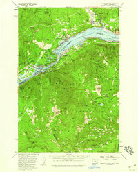 1957 Bonneville Dam1959 Print · USGSThe Columbia River Gorge in the late fifties was a landscape of industrial power and remote forest trails. Map collectors can trace the mid-century footprints of Stevenson and Cascade Locks or locate landmarks like St Martins Hot Springs and the Bridge of the Gods.2 unique versions available
 - 1958 Map of Vancouver, 1968 Print
 1958 Vancouver1968 Print · USGSThe Lower Columbia and Willamette valleys thrive in the late sixties as major rail and river hubs. Genealogists and historians can trace the development of Portland, identify the grounds of Camp Withycombe, and locate coastal landmarks from Tillamook Head to Garibaldi.3 unique versions available
 - 1964 Map of Vancouver
 1964 Vancouver1964 Print · USGSThe Pacific Northwest interior and coast are shown here in the 1960s, from the Portland metropolitan hub to the rugged Pacific shoreline. Researchers can trace the legacy of the Grand Ronde Indian Reservation, the early layout of McMinnville, and the maritime approaches near Tillamook Head.
 - 1979 Map of Bonneville Dam
 1979 Bonneville Dam1979 Print · USGSThe Columbia River Gorge in the late seventies reveals a landscape of massive hydroelectric works and timbered peaks. Genealogists and historians can trace the riverside towns of Stevenson and Cascade Locks or locate the site of the Bonneville Dam.
 - 1979 Map of Vancouver, 1980 Print
 1979 Vancouver1980 Print · USGSThe Portland and Vancouver metropolitan area is captured here in the late seventies, showing the dense nexus of river, rail, and air transit. Genealogists and local historians can trace the footprints of Vancouver Barracks, Lincoln Memorial Park Cem, and the old rail lines of the Burlington Northern.2 unique versions available
 - 1982 Map of Hood River, 1983 Print
 1982 Hood River1983 Print · USGSThe Columbia River Gorge in the early eighties shows a landscape shaped by massive hydroelectric projects and deep-rooted timber communities. Researchers can trace the rail-and-river network through Cascade Locks and The Dalles Dam, or explore the terrain of Gifford Pinchot National Forest.
 - 1986 Map of Beacon Rock
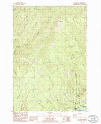 1986 Beacon Rock1986 Print · USGSSkamania County's Columbia River Gorge appears here in the mid-eighties as a hub of recreation and utility. You can trace the Pacific Crest National Scenic Trail past Hardy Falls and locate old landmarks like Hamilton Mtn and the Three Corner Rock Trailhead.2 unique versions available
 - 1994 Map of Bonneville Dam, 1996 Print
 1994 Bonneville Dam1996 Print · USGSThe Columbia River Gorge in the mid-nineties shows a landscape defined by massive hydropower and river traffic. Researchers can trace the engineering footprint of Bonneville Dam, find the Iman Cem, and follow the Bridge of the Gods into Cascade Locks.
 - 1994 Map of Beacon Rock, 1996 Print
 1994 Beacon Rock1996 Print · USGSThe northern banks of the Columbia River Gorge appear in great detail during the mid-nineties, showing a landscape dedicated to conservation and hiking. Hikers and historians can trace the Pacific Crest National Scenic Trail as it passes Three Corner Rock and Hardy Falls.
 - 2011 Map of Bonneville Dam, 2011 Print
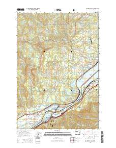
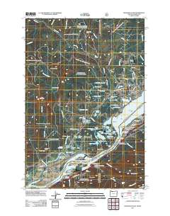 2011 Bonneville Dam2011 Print · USGSCovers North Bonneville, including Stevenson, Cascade Locks, and other nearby areas
 - 2014 Map of Bonneville Dam, 2014 Print
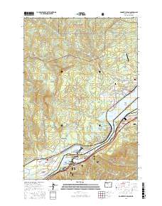
 2014 Bonneville Dam2014 Print · USGSCovers North Bonneville, including Stevenson, Cascade Locks, and other nearby areas
 - 2017 Map of Bonneville Dam, 2017 Print
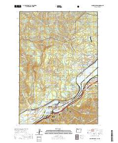
 2017 Bonneville Dam2017 Print · USGSCovers North Bonneville, including Stevenson, Cascade Locks, and other nearby areas
 - 2020 Map of Bonneville Dam, 2020 Print
 2020 Bonneville Dam2020 Print · USGSCovers North Bonneville, including Stevenson, Cascade Locks, and other nearby areas
 - 2023 Map of Bonneville Dam, 2023 Print
 2023 Bonneville Dam2023 Print · USGSCovers North Bonneville, including Stevenson, Cascade Locks, and other nearby areas
 - 2023 Map of Beacon Rock, 2023 Print
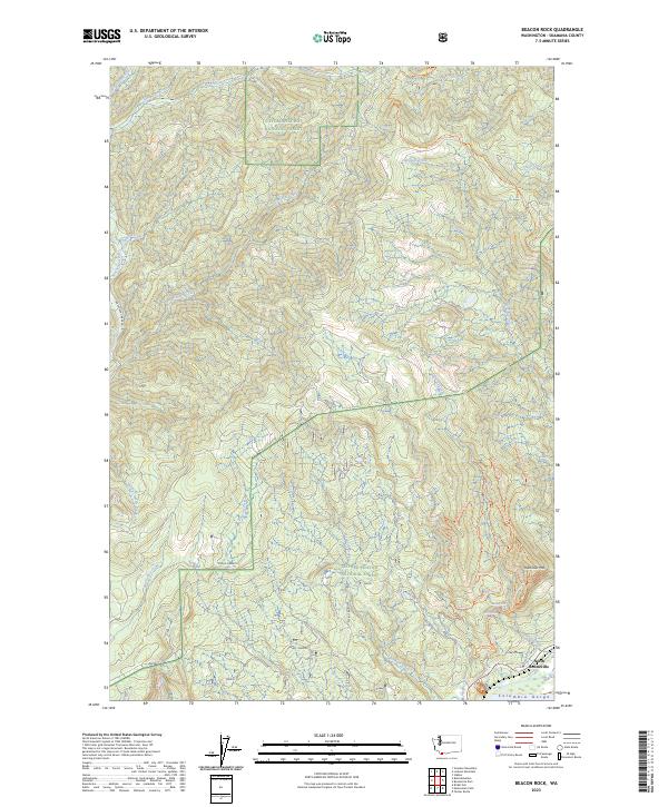 2023 Beacon Rock2023 Print · USGSNorth Bonneville and the Columbia Gorge shoreline are documented in this contemporary survey of the Skamania County wilderness. Researchers can trace modern trail systems and water features like Rodney Falls, Mars Landing, and Cedar Swamps.
 - 2024 Map of Bonneville Dam, 2024 Print
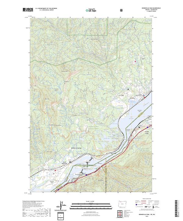
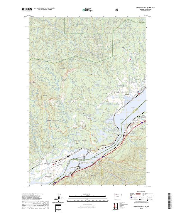 2024 Bonneville Dam2024 Print · USGSThe Columbia River Gorge comes to life on this map, showing the towns of Stevenson and North Bonneville along the river's edge. Researchers can locate specific sites like Iman Cem, Fort Rains, and the Freddie Masterson Grave amidst the sprawling forest terrain.
End of results
Showing maps 1-25 of 25
Top cities near North Bonneville
Frequently asked questions
- What are the different types of historical maps available for North Bonneville?
- What is the oldest map of North Bonneville?
- Where can I purchase historical maps of North Bonneville for my home or office?
- Where can I download high-res historical maps of North Bonneville?
- Are there historical topographic maps available for North Bonneville?
- Is there historical aerial imagery available for North Bonneville?
- Where are historical maps of North Bonneville sourced from?