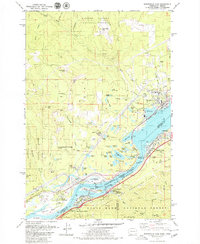
1979 Map of Bonneville Dam
USGS Topo · Published 1979About this map
Bonneville Dam anchors this landscape where the Columbia River separates Washington and Oregon. During this period in the late 1970s, the map documents significant infrastructure including a powerhouse under construction and extensive fish ladders at Bradford Island. The settlement of North Bonneville sits at the river’s edge, adjacent to the Burlington Northern railroad line that follows the northern bank. Across the water, Cascade Locks serves as a hub for river transit and aviation via the Cascade Locks Airport.
Find a feature on this map
90 named features on this map. Tap any name to fly to it.
Don’t see what you’re looking for? This feature index may not catch every label — zoom into the map to look around manually.
Map Details
Editions of this 1979 Bonneville Dam Map
This is the sole edition of this map. No revisions or reprints were ever made.
Other maps of this area

1926 · Hood River
USGS Topo · 1:125,000

1929 · Hood River
USGS Topo · 1:125,000

1940 · Lookout Mtn
USGS Topo · 1:62,500

1948 · Vancouver
USGS Topo · 1:250,000

1950 · Vancouver
USGS Topo · 1:250,000

1950 · Vancouver
USGS Topo · 1:250,000

1953 · Lookout Mtn
USGS Topo · 1:62,500

1953 · The Dalles
USGS Topo · 1:250,000

1954 · Bridal Veil
USGS Topo · 1:62,500

1956 · The Dalles
USGS Topo · 1:250,000