1900s (20th Century) Maps of Monroe, Washington
Explore 17 historic maps of Monroe from the 1900s (20th Century). These maps offer a rare glimpse into what life looked like during the 1900s — showing old roads, neighborhoods, homes, and landmarks that have changed or disappeared over time.
Whether you're researching your family's past, planning a metal detecting trip, or studying how Monroe's landscape evolved across the 1900s, these high-resolution maps are a powerful tool for exploring the history of this region.
- Focus on a specific era: All maps on this page are from the 1900s, giving you a focused view of this time period.
- See what’s changed: Compare century-old streets, trails, and buildings to today's modern landscape using overlays and satellite layers.
- Research with precision: Use these maps for genealogy, historical research, land use analysis, or educational projects.
- View, download, or print: Maps are fully viewable online in high resolution, and can be downloaded or printed for your own records.
Start exploring Monroe's history through authentic maps from the 1900s. This is your window into the past.
Monroe, WA maps
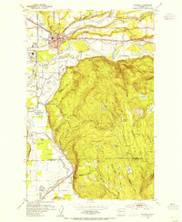
(17)- 1921 Map of Sultan
 1921 Sultan1921 Print · USGSThe Snoqualmie and Skykomish river valleys are defined by timber and rail in the 1920s. Researchers can trace early industry through the Apex Mines, Coke Ovens, and rural schools like Mountain View School.4 unique versions available
 - 1923 Map of Sultan
 1923 Sultan1923 Print · USGSThe Skykomish and Snoqualmie river valleys thrive in the early twenties as centers of timber and rail. Genealogists can trace family roots through rural sites like Forest Glade School or follow the Lumber RR lines to the Apex Mines.4 unique versions available
 - 1944 Map of Everett
 1944 Everett1944 Print · USGSMid-century Snohomish County shows a landscape of industrial riverfronts and rural schoolhouses during the Second World War. Genealogists can trace family names at Cypress Lawn Cem, locate the CCC Camp, or find old school sites like Forbes Sch.
 - 1953 Map of Monroe, 1955 Print
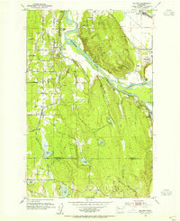
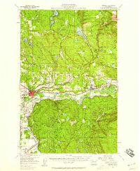
 1953 Monroe1955 Print · USGSMonroe and the fertile Skykomish River valley are seen here in the early fifties during a period of industrial and institutional growth. Researchers can trace the Milwaukee Road rail lines or locate landmarks like the State Reformatory and the Evergreen State Fairgrounds.4 unique versions available
 - 1953 Map of Maltby, 1955 Print
 1953 Maltby1955 Print · USGSSnohomish County in the early fifties shows a transition from river-valley agriculture to upland settlement near the three great river forks. Genealogists and historians can trace the State Reformatory, the Paradise Valley Cem, and old rail stops at Cathcart and Maltby.5 unique versions available
 - 1953 Map of Snohomish, 1955 Print
 1953 Snohomish1955 Print · USGSSnohomish and the river valleys of the Pilchuck and Snohomish are caught in a period of post-war growth and industrial transit. Genealogists and local historians can locate family landmarks like the Fobes Sanatorium, Mt Carmel Cemetery, and the Pleasant View Ranch.5 unique versions available
 - 1953 Map of Everett, 1958 Print
 1953 Everett1958 Print · USGSSnohomish County and the northern edge of King County are shown here during the post-war expansion of the mid-fifties. Researchers can trace the legacy of the timber and rail era through landmarks like the Great Northern Railway, Snohomish Airfield, and the Marshland Sch (Aban'd).2 unique versions available
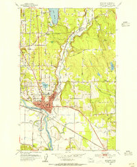
 - 1956 Map of Monroe, 1958 Print
 1956 Monroe1958 Print · USGSSnohomish County in the mid-fifties shows a landscape of river-valley agriculture and upland timber. Trace the Great Northern rail lines through Monroe and Sultan, or locate rural landmarks like Wagner Sch and the State Reformatory.2 unique versions available
 - 1957 Map of Wenatchee, 1973 Print
 1957 Wenatchee1973 Print · USGSThe northern Cascades and Columbia River valley appear here in the mid-fifties, showing the region's critical rail and transit corridors. Researchers can trace the routes of the Great Northern RR and Milwaukee Road through settlements like Skykomish, Baring, and Dryden.2 unique versions available
 - 1958 Map of Seattle, 1966 Print
 1958 Seattle1966 Print · USGSThe Puget Sound region in the mid-fifties showcases a balance of urban growth and Olympic wilderness. Trace the industrial waterfronts of Tacoma, old naval facilities like Keyport Naval Res, and mountain peaks like Mount Constance.3 unique versions available
 - 1962 Map of Seattle
 1962 Seattle1962 Print · USGSThe Puget Sound region and Olympic Peninsula are shown at a peak of mid-century growth. Genealogists and historians can trace rail lines like the Pacific Coast RR or locate landmarks such as Fort Lawton and the Bothell Power Station.
 - 1975 Map of Skykomish River, 1977 Print
 1975 Skykomish River1977 Print · USGSThe Cascades meet the river valleys in the mid-seventies, showing the vital rail corridors and mountain towns along the Skykomish River. Researchers can trace the path of the Pacific Crest National Scenic Trail and locate historic sites like State Reformatory Farm No 2 and the Old Cascade Tunnel.2 unique versions available
 - 1975 Map of Seattle, 1977 Print
 1975 Seattle1977 Print · USGSThe Puget Sound region in the mid-seventies shows a landscape of rapid suburban growth and vital maritime industry. Researchers can trace the development of Eastside hubs like Bellevue or examine the rail and naval infrastructure of Bremerton and Paine Field.
 - 1989 Map of Lake Roesiger
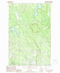 1989 Lake Roesiger1989 Print · USGSSnohomish County’s lake country is captured here in the late eighties, showing a landscape of timbered hills and burgeoning rural settlements. Genealogists and hikers can trace old property lines near Forest Glade, explore the shores of Lake Roesiger, or locate the Sub Station near Wagner.
 - 1992 Map of Seattle, 1993 Print
 1992 Seattle1993 Print · USGSThe Seattle metropolitan area and Puget Sound are shown here in the early nineties during a period of rapid suburban and technological growth. Researchers can trace the development of Mercer Island, locate the Bangor Naval Submarine Base, and study the industrial layout of Boeing Field.2 unique versions available
 - 1993 Map of Monroe
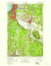
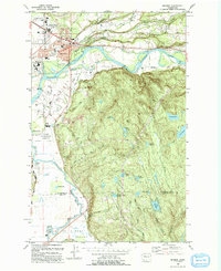 1993 Monroe1993 Print · USGSThe Skykomish and Snoqualmie valleys meet here in the early nineties, showing a region defined by river-borne transit and state institutions. Trace family history at the IOOF Cem, or locate the State Reformatory and the Evergreen State Fairground.
 - 1997 Map of Lake Roesiger, 2003 Print
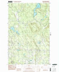 1997 Lake Roesiger2003 Print · USGSSnohomish County in the late nineties is a landscape of lakeside parks and timbered hills. Researchers can trace the development of Lake Roesiger and find old settlements like Forest Glade and Wagner alongside Three Lakes Hill.
End of results
Showing maps 1-17 of 17
Top cities near Monroe
- Bellevue historical maps
- Everett historical maps
- Kirkland historical maps
- Redmond historical maps
- Marysville historical maps
- Sammamish historical maps
See more
Frequently asked questions
- What are the different types of historical maps available for Monroe?
- What is the oldest map of Monroe?
- Where can I purchase historical maps of Monroe for my home or office?
- Where can I download high-res historical maps of Monroe?
- Are there historical topographic maps available for Monroe?
- Is there historical aerial imagery available for Monroe?
- Where are historical maps of Monroe sourced from?