1950s Maps of Monroe, Washington
Explore 7 historic maps of Monroe from the 1950s. These maps offer a rare glimpse into what life looked like during the 1950s — showing old roads, neighborhoods, homes, and landmarks that have changed or disappeared over time.
Whether you're researching your family's past, planning a metal detecting trip, or studying how Monroe's landscape evolved across the 1950s, these high-resolution maps are a powerful tool for exploring the history of this region.
- Focus on a specific era: All maps on this page are from the 1950s, giving you a focused view of this time period.
- See what’s changed: Compare century-old streets, trails, and buildings to today's modern landscape using overlays and satellite layers.
- Research with precision: Use these maps for genealogy, historical research, land use analysis, or educational projects.
- View, download, or print: Maps are fully viewable online in high resolution, and can be downloaded or printed for your own records.
Start exploring Monroe's history through authentic maps from the 1950s. This is your window into the past.
Monroe, WA maps
(7)- 1953 Map of Monroe, 1955 Print
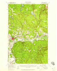
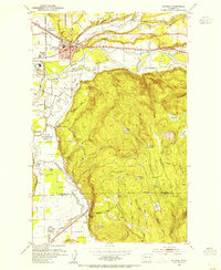 1953 Monroe1955 Print · USGSMonroe and the fertile Skykomish River valley are seen here in the early fifties during a period of industrial and institutional growth. Researchers can trace the Milwaukee Road rail lines or locate landmarks like the State Reformatory and the Evergreen State Fairgrounds.4 unique versions available
 - 1953 Map of Maltby, 1955 Print
 1953 Maltby1955 Print · USGSSnohomish County in the early fifties shows a transition from river-valley agriculture to upland settlement near the three great river forks. Genealogists and historians can trace the State Reformatory, the Paradise Valley Cem, and old rail stops at Cathcart and Maltby.5 unique versions available
 - 1953 Map of Snohomish, 1955 Print
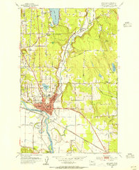 1953 Snohomish1955 Print · USGSSnohomish and the river valleys of the Pilchuck and Snohomish are caught in a period of post-war growth and industrial transit. Genealogists and local historians can locate family landmarks like the Fobes Sanatorium, Mt Carmel Cemetery, and the Pleasant View Ranch.5 unique versions available
 - 1953 Map of Everett, 1958 Print
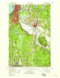 1953 Everett1958 Print · USGSSnohomish County and the northern edge of King County are shown here during the post-war expansion of the mid-fifties. Researchers can trace the legacy of the timber and rail era through landmarks like the Great Northern Railway, Snohomish Airfield, and the Marshland Sch (Aban'd).2 unique versions available
 - 1956 Map of Monroe, 1958 Print
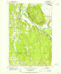
 1956 Monroe1958 Print · USGSSnohomish County in the mid-fifties shows a landscape of river-valley agriculture and upland timber. Trace the Great Northern rail lines through Monroe and Sultan, or locate rural landmarks like Wagner Sch and the State Reformatory.2 unique versions available
 - 1957 Map of Wenatchee, 1973 Print
 1957 Wenatchee1973 Print · USGSThe northern Cascades and Columbia River valley appear here in the mid-fifties, showing the region's critical rail and transit corridors. Researchers can trace the routes of the Great Northern RR and Milwaukee Road through settlements like Skykomish, Baring, and Dryden.2 unique versions available
 - 1958 Map of Seattle, 1966 Print
 1958 Seattle1966 Print · USGSThe Puget Sound region in the mid-fifties showcases a balance of urban growth and Olympic wilderness. Trace the industrial waterfronts of Tacoma, old naval facilities like Keyport Naval Res, and mountain peaks like Mount Constance.3 unique versions available
End of results
Showing maps 1-7 of 7
Top cities near Monroe
- Bellevue historical maps
- Everett historical maps
- Kirkland historical maps
- Redmond historical maps
- Marysville historical maps
- Sammamish historical maps
See more
Frequently asked questions
- What are the different types of historical maps available for Monroe?
- What is the oldest map of Monroe?
- Where can I purchase historical maps of Monroe for my home or office?
- Where can I download high-res historical maps of Monroe?
- Are there historical topographic maps available for Monroe?
- Is there historical aerial imagery available for Monroe?
- Where are historical maps of Monroe sourced from?