1980s Maps of Pilchuck, Washington
Explore 1 historic maps of Pilchuck from the 1980s. These maps offer a rare glimpse into what life looked like during the 1980s — showing old roads, neighborhoods, homes, and landmarks that have changed or disappeared over time.
Whether you're researching your family's past, planning a metal detecting trip, or studying how Pilchuck's landscape evolved across the 1980s, these high-resolution maps are a powerful tool for exploring the history of this region.
- Focus on a specific era: All maps on this page are from the 1980s, giving you a focused view of this time period.
- See what’s changed: Compare century-old streets, trails, and buildings to today's modern landscape using overlays and satellite layers.
- Research with precision: Use these maps for genealogy, historical research, land use analysis, or educational projects.
- View, download, or print: Maps are fully viewable online in high resolution, and can be downloaded or printed for your own records.
Start exploring Pilchuck's history through authentic maps from the 1980s. This is your window into the past.
Pilchuck, WA maps
(1)- 1989 Map of Granite Falls
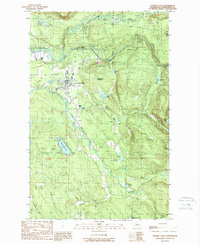 1989 Granite Falls1989 Print · USGSGranite Falls and the surrounding Snohomish County river valleys are captured here in the late eighties as timber lands met growing rural development. Genealogists and hikers can locate family landmarks like Bosworth Lake, the local Cem, and the winding Pilchuck River.2 unique versions available
End of results
Showing maps 1-1 of 1
Top cities near Pilchuck
- Everett historical maps
- Marysville historical maps
- Lake Stevens historical maps
- Arlington historical maps
- Monroe historical maps
- Maltby historical maps
See more
Frequently asked questions
- What are the different types of historical maps available for Pilchuck?
- What is the oldest map of Pilchuck?
- Where can I purchase historical maps of Pilchuck for my home or office?
- Where can I download high-res historical maps of Pilchuck?
- Are there historical topographic maps available for Pilchuck?
- Is there historical aerial imagery available for Pilchuck?
- Where are historical maps of Pilchuck sourced from?