1950s Maps of Colville, Washington
Explore 3 historic maps of Colville from the 1950s. These maps offer a rare glimpse into what life looked like during the 1950s — showing old roads, neighborhoods, homes, and landmarks that have changed or disappeared over time.
Whether you're researching your family's past, planning a metal detecting trip, or studying how Colville's landscape evolved across the 1950s, these high-resolution maps are a powerful tool for exploring the history of this region.
- Focus on a specific era: All maps on this page are from the 1950s, giving you a focused view of this time period.
- See what’s changed: Compare century-old streets, trails, and buildings to today's modern landscape using overlays and satellite layers.
- Research with precision: Use these maps for genealogy, historical research, land use analysis, or educational projects.
- View, download, or print: Maps are fully viewable online in high resolution, and can be downloaded or printed for your own records.
Start exploring Colville's history through authentic maps from the 1950s. This is your window into the past.
Colville, WA maps
(3)- 1952 Map of White Mud Lake, 1954 Print
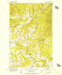 1952 White Mud Lake1954 Print · USGSThe northern reaches of Stevens County in the 1950s show a rugged frontier landscape of active mining and early settlement sites. Genealogists and historians can trace the foundations of Pinkney City or locate rural landmarks like the Fort Colville Grange and the Old Dominion Mine.4 unique versions available
 - 1952 Map of Colville, 1954 Print
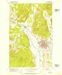 1952 Colville1954 Print · USGSIn the early fifties, Colville was a thriving hub of the Pacific Northwest, balancing its role as a county seat with heavy rail and timber industries. Genealogists can trace the Phipps Homestead or search for family sites near the Highland Sch and Evergreen Cem.3 unique versions available
 - 1958 Map of Sandpoint, 1966 Print
 1958 Sandpoint1966 Print · USGSThe Idaho Panhandle and Northeast Washington are shown here in the late fifties, when timber and hydroelectric power drove the local economy. Trace family roots in rail-side towns like Cusick or Metaline Falls, and locate landmarks like the Albeni Falls Dam or Falls Ranger Station.2 unique versions available
End of results
Showing maps 1-3 of 3
Top cities near Colville
Frequently asked questions
- What are the different types of historical maps available for Colville?
- What is the oldest map of Colville?
- Where can I purchase historical maps of Colville for my home or office?
- Where can I download high-res historical maps of Colville?
- Are there historical topographic maps available for Colville?
- Is there historical aerial imagery available for Colville?
- Where are historical maps of Colville sourced from?