1940s Maps of Four Corners, Washington
Explore 2 historic maps of Four Corners from the 1940s. These maps offer a rare glimpse into what life looked like during the 1940s — showing old roads, neighborhoods, homes, and landmarks that have changed or disappeared over time.
Whether you're researching your family's past, planning a metal detecting trip, or studying how Four Corners's landscape evolved across the 1940s, these high-resolution maps are a powerful tool for exploring the history of this region.
- Focus on a specific era: All maps on this page are from the 1940s, giving you a focused view of this time period.
- See what’s changed: Compare century-old streets, trails, and buildings to today's modern landscape using overlays and satellite layers.
- Research with precision: Use these maps for genealogy, historical research, land use analysis, or educational projects.
- View, download, or print: Maps are fully viewable online in high resolution, and can be downloaded or printed for your own records.
Start exploring Four Corners's history through authentic maps from the 1940s. This is your window into the past.
Four Corners, WA maps
(2)- 1944 Map of Yelm
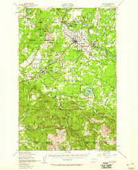
 1944 Yelm1944 Print · USGSThe Nisqually River valley and the surrounding prairies are captured here during the 1940s as military and rail infrastructure reshaped the landscape. Researchers can trace the rail corridors of the Northern Pacific, the Centralia Power Plant, and local landmarks like Collins Sch and Vail.2 unique versions available
 - 1949 Map of Yelm, 1958 Print
 1949 Yelm1958 Print · USGSYelm and the surrounding prairies of Thurston and Pierce counties are shown here just after the war. Researchers can trace family ranching sites like Fox Ranch, early schools such as Collins School, and the heavy rail activity at McKenna.
End of results
Showing maps 1-2 of 2
Top cities near Four Corners
- Lakewood historical maps
- Lacey historical maps
- Parkland historical maps
- Spanaway historical maps
- Frederickson historical maps
- Elk Plain historical maps
See more
Frequently asked questions
- What are the different types of historical maps available for Four Corners?
- What is the oldest map of Four Corners?
- Where can I purchase historical maps of Four Corners for my home or office?
- Where can I download high-res historical maps of Four Corners?
- Are there historical topographic maps available for Four Corners?
- Is there historical aerial imagery available for Four Corners?
- Where are historical maps of Four Corners sourced from?