1940s Maps of Altoona, Washington
Explore 2 historic maps of Altoona from the 1940s. These maps offer a rare glimpse into what life looked like during the 1940s — showing old roads, neighborhoods, homes, and landmarks that have changed or disappeared over time.
Whether you're researching your family's past, planning a metal detecting trip, or studying how Altoona's landscape evolved across the 1940s, these high-resolution maps are a powerful tool for exploring the history of this region.
- Focus on a specific era: All maps on this page are from the 1940s, giving you a focused view of this time period.
- See what’s changed: Compare century-old streets, trails, and buildings to today's modern landscape using overlays and satellite layers.
- Research with precision: Use these maps for genealogy, historical research, land use analysis, or educational projects.
- View, download, or print: Maps are fully viewable online in high resolution, and can be downloaded or printed for your own records.
Start exploring Altoona's history through authentic maps from the 1940s. This is your window into the past.
Altoona, WA maps
(2)- 1940 Map of Brookfield
 1940 Brookfield1940 Print · USGSPacific and Wahkiakum Counties are shown in detail during the early 1940s, highlighting the heavy industrial presence along the Columbia River shoreline. Researchers can locate salmon canneries, logging camps, and family holdings such as the Pillar Rock Cannery, Old Camp Brix Logging Co, and Maki Ranch.
 - 1949 Map of Rosburg, 1955 Print
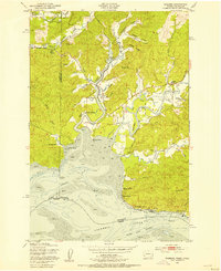 1949 Rosburg1955 Print · USGSCoastal Wahkiakum County is depicted here in the late 1940s as a landscape of tidewater sloughs and river landings. Genealogists and historians can trace riverside settlements at Rosburg, Altoona, and Oneida, or locate landmarks like Old Camp Brix and the Rosburg Sch.3 unique versions available
End of results
Showing maps 1-2 of 2
Top cities near Altoona
Frequently asked questions
- What are the different types of historical maps available for Altoona?
- What is the oldest map of Altoona?
- Where can I purchase historical maps of Altoona for my home or office?
- Where can I download high-res historical maps of Altoona?
- Are there historical topographic maps available for Altoona?
- Is there historical aerial imagery available for Altoona?
- Where are historical maps of Altoona sourced from?