Old Maps of Barbour County, West Virginia for Academic Research
Study the evolution of Barbour County with 69 high-resolution historic maps. Whether you're teaching, researching, or modeling changes in land use, these maps provide essential visual documentation of urban, environmental, and geographic change.
- Analyze long-term change: Track patterns in development, transportation, and natural features.
- Ideal for environmental or urban studies: Support academic projects with primary historical map data.
- Use in the classroom or lab: Educators and researchers rely on these maps to bring historical context to life.
These maps are a powerful tool for teaching, research, and visualizing how Barbour County has changed over the decades.
Barbour County, WV maps
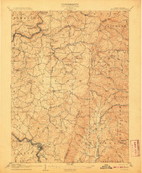
(69)- 1886 Map of St. George
 1886 St. George1886 Print · USGSNorthern West Virginia’s rugged river valleys and early rail corridors are mapped here in the mid-1880s. Genealogists can trace family roots in settlements like St George or Terra Alta, while following the path of the Baltimore and Ohio Railroad.
 - 1889 Map of Beverly
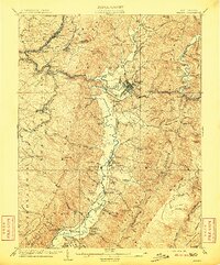
 1889 Beverly1889 Print · USGSThe high Allegheny ridges and river forks of West Virginia are mapped here in the late 1880s, highlighting the rugged settlement patterns of Randolph and Pocahontas counties. Researchers can trace early family-named locations such as Days Mills, locate the Boundary Line In Dispute, and find remote outposts like Traveller's Repose.
 - 1891 Map of St. George, 1895 Print
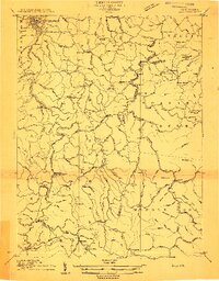
 1891 St. George1895 Print · USGSNorthern West Virginia at the end of the nineteenth century was defined by the expansion of the Baltimore and Ohio Railroad. Genealogists can trace early homesteads and landmarks like Valley Furnace, St George, and Terra Alta.3 unique versions available
 - 1892 Map of Beverly
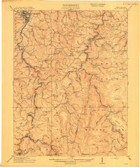
 1892 Beverly1892 Print · USGSCentral West Virginia's high-mountain settlements and disputed county lines are captured here in the late nineteenth century. Genealogists and historians can trace family locations and early industry near Beverly, Huttonsville, and the remote Days Mills.5 unique versions available
 - 1893 Map of Buckhannon
 1893 Buckhannon1893 Print · USGSCentral West Virginia at the end of the nineteenth century shows a network of upland farms and timber-adjacent rail lines. Genealogists can trace family names through landmarks like Alkire Mill, Buckwheat Church, and settlements like Vandalia (Austin).
 - 1896 Map of Buckhannon, 1902 Print
 1896 Buckhannon1902 Print · USGSUpshur and Randolph counties appear here in the late nineteenth century as a landscape of remote mountain settlements and winding river valleys. Genealogists can trace early homesteads and community hubs like Alkires Mill, Hacker Valley, and French Creek before modern development.3 unique versions available
 - 1897 Map of Buckhannon
 1897 Buckhannon1897 Print · USGSUpshur and Randolph counties appear here in the late nineteenth century as a landscape of isolated ridge-top settlements and river-bottom mills. Genealogists can trace family roots through landmarks like Alkires Mill, Goshen Church, and the oddly named Pumpkin Town.
 - 1902 Map of Fairmont
 1902 Fairmont1902 Print · USGSMarion and Taylor Counties were hubs of coal and transit at the opening of the twentieth century, as the rail lines followed the winding rivers. Genealogists can trace early family settlements and work sites from the Tyrconnell Mines to rural Nebo Church and Boothsville.4 unique versions available
 - 1904 Map of Philippi
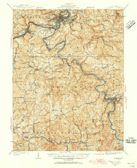
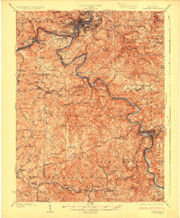
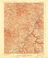
 1904 Philippi1904 Print · USGSBarbour and Upshur counties are shown during a period of coal-driven growth and rural stability just after the turn of the century. Trace the early industrial footprints of Berryburg and Century, or locate family landmarks like Peter's Mill and the Burnersville Volga P.O..2 unique versions available
 - 1907 Map of Thornton
 1907 Thornton1907 Print · USGSPreston and Taylor counties are depicted here in the early years of the century as the rail industry reshaped the Appalachian highlands. Genealogists can trace family roots at specific landmarks like Summers Church, Knottsville, and Slabtown Schoolhouse along the Baltimore and Ohio RR corridor.2 unique versions available
 - 1907 Map of Belington
 1907 Belington1907 Print · USGSBelington was a bustling railway hub at the turn of the century where multiple rail lines met the Tygart River. Genealogists can locate family homesteads near landmarks like Olive Hill Schoolhouse, Wilmoth Ford, and the old Turnpike.2 unique versions available
 - 1909 Map of Elkins
 1909 Elkins1909 Print · USGSRandolph County's river valleys and mountain ridges are captured here during the peak of the regional railroad and timber era. Genealogists can trace family roots through numerous named schools and churches, from Trinity Church to the Goff School, while following the paths of the Coal and Coke Ry and Staunton and Parkersburg Pike.4 unique versions available
 - 1912 Map of Sago
 1912 Sago1912 Print · USGSThe Buckhannon River valley was a bustling corridor for the Baltimore and Ohio Railroad in the early twentieth century. Genealogists can trace family names and remote post offices at Beans Mill Indian Camp PO, Sago, and Kingsville PO.4 unique versions available
 - 1914 Map of Sago
 1914 Sago1914 Print · USGSUpshur and Randolph counties thrive as centers of the timber and rail trade during the early twentieth century. Genealogists can trace family names through dozens of rural landmarks like Beans Mill Indian Camp, Tallmansville, and the Hanging Run School.4 unique versions available
 - 1923 Map of Fairmont, 1956 Print
 1923 Fairmont1956 Print · USGSMarion and Taylor counties are shown during the height of their rail and coal era in the early twentieth century. Researchers can trace family origins through dozens of named landmarks like Jane Memorial Church, T McConnell Mines, and the river crossing at Benton Ferry.2 unique versions available
 - 1925 Map of Philippi, 1954 Print
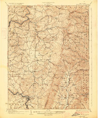
 1925 Philippi1954 Print · USGSIn the mid-1920s, the Tygart River valley was a busy corridor of coal settlements and river commerce. Genealogists can locate family homesteads near vanished landmarks like Brownton PO, Pigtail School, and the Electric Line near Galloway.
 - 1926 Map of Fairmont
 1926 Fairmont1926 Print · USGSMarion and Taylor counties are shown during the mid-twenties when coal mining and the rail industry shaped the river valleys. Researchers can locate vanished landmarks like the Tyrconnell Mines and community centers such as Pruntytown and Mt Zion Church.3 unique versions available
 - 1926 Map of Thornton
 1926 Thornton1926 Print · USGSPreston and Taylor counties show a dense network of mountain settlements and rail corridors in the mid-1920s. Genealogists can locate family landmarks such as Slabcamp Church, the Pell School, and rail-side towns like Tunnelton or Newburg.2 unique versions available
 - 1927 Map of Belington
 1927 Belington1927 Print · USGSNorth Central West Virginia is documented here in the late twenties as a network of ridge-top schools and river-bottom rail hubs. Genealogists can trace family landmarks and local institutions like Vannoy's Mill, Valley Furnace, and Moatsville Sta.2 unique versions available
 - 1928 Map of Philippi
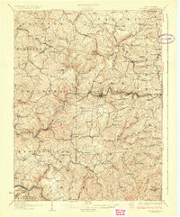
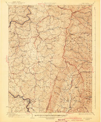
 1928 Philippi1928 Print · USGSBarbour County is shown here in the mid-twenties as the Baltimore and Ohio railroad connected river towns and coal camps. Researchers can trace ancestral roots through dozens of local landmarks like Adaland, Rangoon PO, and the Pleasant Grove Church.2 unique versions available
 - 1941 Map of Belington
 1941 Belington1941 Print · USGSBarbour and Randolph counties are shown here during the pre-war era as the Baltimore and Ohio railroad powered the local economy. Genealogists can trace family homesteads near dozens of landmarks including Vannoys Mill, Kalamazoo, and St Joseph School.
 - 1948 Map of Cumberland
 1948 Cumberland1948 Print · USGSMid-century Appalachia and the Shenandoah Valley are shown in detail, documenting the industrial and transportation hubs of the tri-state area. Genealogists can trace family roots through settlements like Double Tollgate and Bunker Hill or along the Baltimore & Ohio RR.3 unique versions available
 - 1949 Map of Charlottesville
 1949 Charlottesville1949 Print · USGSThe Shenandoah Valley and Blue Ridge appear in the late 1940s as a thriving corridor of rail and river commerce. Researchers can trace the mid-century footprints of Harrisonburg, Staunton, and Culpeper alongside the historic routes of the Southern Railway.2 unique versions available
 - 1949 Map of Clarksburg
 1949 Clarksburg1949 Print · USGSThe upper Ohio River valley and the industrial heart of West Virginia come into focus during this post-war period. Genealogists and researchers can trace the rail corridors of the Baltimore and Ohio and locate centers like Fairmont, Grafton, and Waynesburg.
 - 1952 Map of Cumberland
 1952 Cumberland1952 Print · USGSThe Potomac Highlands and the Shenandoah Valley are revealed in this early 1950s survey of the Appalachian interior. Researchers can trace the river-and-rail corridors connecting Cumberland, Winchester, and the recreational waters of Deep Creek Lake.
Showing maps 1-25 of 69
Top cities of Barbour County
Frequently asked questions
- What are the different types of historical maps available for Barbour County?
- What is the oldest map of Barbour County?
- Where can I purchase historical maps of Barbour County for my home or office?
- Where can I download high-res historical maps of Barbour County?
- Are there historical topographic maps available for Barbour County?
- Is there historical aerial imagery available for Barbour County?
- Where are historical maps of Barbour County sourced from?