1990s Maps of Barbour County, West Virginia
Explore 2 historic maps of Barbour County from the 1990s. These maps offer a rare glimpse into what life looked like during the 1990s — showing old roads, neighborhoods, homes, and landmarks that have changed or disappeared over time.
Whether you're researching your family's past, planning a metal detecting trip, or studying how Barbour County's landscape evolved across the 1990s, these high-resolution maps are a powerful tool for exploring the history of this region.
- Focus on a specific era: All maps on this page are from the 1990s, giving you a focused view of this time period.
- See what’s changed: Compare century-old streets, trails, and buildings to today's modern landscape using overlays and satellite layers.
- Research with precision: Use these maps for genealogy, historical research, land use analysis, or educational projects.
- View, download, or print: Maps are fully viewable online in high resolution, and can be downloaded or printed for your own records.
Start exploring Barbour County's history through authentic maps from the 1990s. This is your window into the past.
Barbour County, WV maps
(2)- 1995 Map of Colebank, 1998 Print
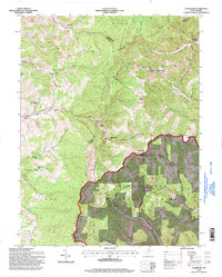 1995 Colebank1998 Print · USGSThe high ridges of Barbour and Tucker Counties come into focus in the mid-nineties as the Monongahela National Forest meets rural valley life. Genealogists and local historians can trace family roots through landmarks like Valley Furnace, Union Chapel, and the Digman Sch.
 - 1995 Map of Montrose, 1998 Print
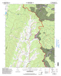 1995 Montrose1998 Print · USGSThe West Virginia highlands near Montrose are captured here in the mid-1990s as the Monongahela National Forest meets valley settlements. Genealogists and local historians can trace rural landmarks from Union Chapel to the community of Smith Crossing and the Elkins Speedway.
End of results
Showing maps 1-2 of 2
Top cities of Barbour County
Frequently asked questions
- What are the different types of historical maps available for Barbour County?
- What is the oldest map of Barbour County?
- Where can I purchase historical maps of Barbour County for my home or office?
- Where can I download high-res historical maps of Barbour County?
- Are there historical topographic maps available for Barbour County?
- Is there historical aerial imagery available for Barbour County?
- Where are historical maps of Barbour County sourced from?