1960s Maps of Barbour County, West Virginia
Explore 12 historic maps of Barbour County from the 1960s. These maps offer a rare glimpse into what life looked like during the 1960s — showing old roads, neighborhoods, homes, and landmarks that have changed or disappeared over time.
Whether you're researching your family's past, planning a metal detecting trip, or studying how Barbour County's landscape evolved across the 1960s, these high-resolution maps are a powerful tool for exploring the history of this region.
- Focus on a specific era: All maps on this page are from the 1960s, giving you a focused view of this time period.
- See what’s changed: Compare century-old streets, trails, and buildings to today's modern landscape using overlays and satellite layers.
- Research with precision: Use these maps for genealogy, historical research, land use analysis, or educational projects.
- View, download, or print: Maps are fully viewable online in high resolution, and can be downloaded or printed for your own records.
Start exploring Barbour County's history through authentic maps from the 1960s. This is your window into the past.
Barbour County, WV maps
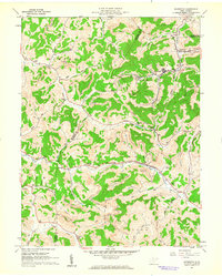
(12)- 1960 Map of Philippi, 1961 Print
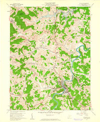 1960 Philippi1961 Print · USGSBarbour County in the early sixties was a landscape of deep river bends and industrial coal production. Trace family roots at Alderson-Broaddus College or find old mining sites near Berryburg and the Baltimore and Ohio rail lines.3 unique versions available
 - 1960 Map of Century, 1961 Print
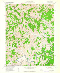 1960 Century1961 Print · USGSBarbour and Upshur counties are shown here at the height of the mid-century coal era. Genealogists can locate family sites like the Rohrbough Cem, rural schoolhouses such as Kesling Sch, and coal company towns like Century No 2.3 unique versions available
 - 1960 Map of Audra, 1962 Print
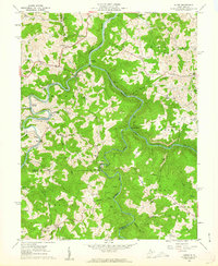 1960 Audra1962 Print · USGSBarbour and Upshur Counties are shown here during the early sixties, a period when mountain rail and river life still defined the region. Genealogists can trace family names through landmarks like Jerusalem Cem, Booth Cem, and the old Mt Hebron Sch.3 unique versions available
 - 1960 Map of Grafton, 1963 Print
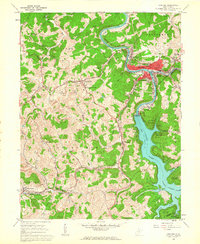 1960 Grafton1963 Print · USGSGrafton and its surrounding Taylor County hills are captured here in the early 1960s, showing a landscape defined by coal, rail, and water. Researchers can trace family roots through the National Cemetery, locate the W Va Industrial School for Boys in Pruntytown, and map the extent of early Strip Mines.3 unique versions available
 - 1961 Map of Clarksburg
 1961 Clarksburg1961 Print · USGSThe mid-century industrial and river landscapes of West Virginia and Ohio are detailed here, centered on the Ohio River. Researchers can trace the Baltimore and Ohio rail lines connecting towns like Parkersburg, Clarksburg, and Monongah.
 - 1961 Map of Charleston
 1961 Charleston1961 Print · USGSWest Virginia's capital region and the highlands to the east are shown in detail during the early sixties. Genealogists and historians can trace rail networks like the Baltimore and Ohio RR and find early state parks such as Watoga State Park.
 - 1961 Map of Cumberland
 1961 Cumberland1961 Print · USGSThe tri-state highlands of Maryland, West Virginia, and Pennsylvania are shown in the mid-twentieth century as a complex landscape of ridges and river valleys. Researchers can trace the winding Potomac River and find old rail-and-river towns like Cumberland, Keyser, and Morgantown.
 - 1961 Map of Brownton, 1962 Print
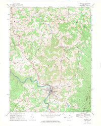
 1961 Brownton1962 Print · USGSCoal mining and rail commerce define the Barbour County landscape in the early sixties. Researchers can trace the Baltimore and Ohio line through Brownton or locate local landmarks like the Covered Bridge and Green Hill Ch.3 unique versions available
 - 1962 Map of Cumberland
 1962 Cumberland1962 Print · USGSThe central Appalachians meet at the height of the mid-century industrial era, showing the rugged topography between Morgantown and Winchester. Genealogists can trace family lands near Fort Necessity or along the vital Baltimore & Ohio RR corridors.
 - 1969 Map of Belington, 1971 Print
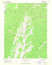
 1969 Belington1971 Print · USGSBarbour County in the late sixties shows a landscape of river-valley commerce and mountain industry. Genealogists and historians can trace rail lines like the Western Maryland and find local landmarks such as Little Bethel Ch, Shawkey Sch, and the Charcoal Ovens.3 unique versions available
 - 1969 Map of Montrose, 1971 Print
 1969 Montrose1971 Print · USGSRandolph and Tucker Counties are seen here in the late sixties as the mountain landscape remained defined by valley farming and timber. Researchers can trace the Maryland Western RR past Montrose to find rural landmarks like Israel Ch and the Elkins Speedway.3 unique versions available
 - 1969 Map of Junior, 1971 Print
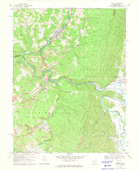 1969 Junior1971 Print · USGSThe coalfields of Barbour and Randolph counties are revealed here in the late sixties as the rail-and-river economy hummed along the Tygart Valley River. Researchers can trace local lineage through Mountain View Cem and old settlements like Coalton, Dartmoor, and Harding.3 unique versions available
End of results
Showing maps 1-12 of 12
Top cities of Barbour County
Frequently asked questions
- What are the different types of historical maps available for Barbour County?
- What is the oldest map of Barbour County?
- Where can I purchase historical maps of Barbour County for my home or office?
- Where can I download high-res historical maps of Barbour County?
- Are there historical topographic maps available for Barbour County?
- Is there historical aerial imagery available for Barbour County?
- Where are historical maps of Barbour County sourced from?