1900s (20th Century) Maps of Berkeley County, West Virginia
Explore 57 historic maps of Berkeley County from the 1900s (20th Century). These maps offer a rare glimpse into what life looked like during the 1900s — showing old roads, neighborhoods, homes, and landmarks that have changed or disappeared over time.
Whether you're researching your family's past, planning a metal detecting trip, or studying how Berkeley County's landscape evolved across the 1900s, these high-resolution maps are a powerful tool for exploring the history of this region.
- Focus on a specific era: All maps on this page are from the 1900s, giving you a focused view of this time period.
- See what’s changed: Compare century-old streets, trails, and buildings to today's modern landscape using overlays and satellite layers.
- Research with precision: Use these maps for genealogy, historical research, land use analysis, or educational projects.
- View, download, or print: Maps are fully viewable online in high resolution, and can be downloaded or printed for your own records.
Start exploring Berkeley County's history through authentic maps from the 1900s. This is your window into the past.
Berkeley County, WV maps
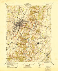
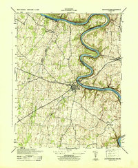
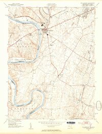
(57)- 1901 Map of Hancock
 1901 Hancock1901 Print · USGSMaryland and West Virginia met at the turn of the century along a busy corridor of river transport and rail expansion. Genealogists can trace family roots through old landmarks like Yeakle Mill, Fairview Church, and early hamlets such as Stotlers Crossroads.8 unique versions available
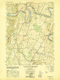
 - 1912 Map of Williamsport
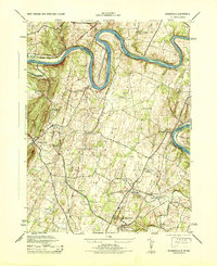
 1912 Williamsport1912 Print · USGSUpper Maryland and the West Virginia panhandle were bustling centers of river and rail transit before the First World War. Researchers can trace the path of the Chesapeake and Ohio Canal and locate family landmarks like Cushwa Mill or the St James School.3 unique versions available
 - 1914 Map of Martinsburg
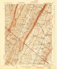
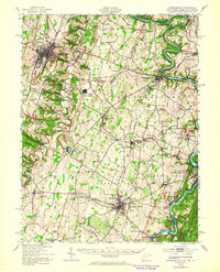
 1914 Martinsburg1914 Print · USGSThe eastern panhandle of West Virginia comes alive in this survey, showing a landscape defined by the Potomac River and burgeoning rail hubs. Genealogists can trace family footprints through dozens of schools and churches, from Shepherdstown to the Snyder Hill Riverside School and John Browns Cave.3 unique versions available
 - 1914 Map of Gerrardstown
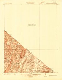
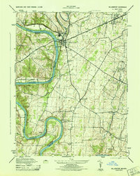
 1914 Gerrardstown1914 Print · USGSBerkeley County was a landscape of mountain ridges and orchard valleys just before the Great War. Researchers can locate vanished landmarks like the Toll Gate at Darkesville or early rural institutions such as the Gerrardstown Colored School.
 - 1916 Map of Gerrardstown
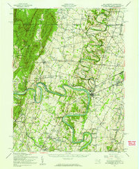
 1916 Gerrardstown1916 Print · USGSThe West Virginia and Virginia borderlands come alive in this mid-1910s study of the ridgelines and valley roads. Genealogists can trace family roots at Salem Church and Tuscarora Church or locate vanished landmarks like the Tollgate and County Home.
 - 1916 Map of Martinsburg
 1916 Martinsburg1916 Print · USGSThe Eastern Panhandle of West Virginia comes to life in the years before the Great War, showing a bustling hub of rail activity and river commerce. Genealogists and historians can trace family roots through schoolhouses like Sutton School and old settlements such as Middleway and Summit Point.4 unique versions available
 - 1937 Map of Gerrardstown
 1937 Gerrardstown1937 Print · USGSSettlements and old wagon roads thread through the Shenandoah Valley in the late 1930s. Genealogists can trace family names and social hubs like Howards Chapel, the Hopewell Meeting House, and the historic Braddock Road.3 unique versions available
 - 1942 Map of Hagerstown
 1942 Hagerstown1942 Print · USGSThe Cumberland Valley and Potomac corridor are captured here at the height of the Second World War rail-and-river era. Genealogists and historians can trace the industrial landscape of Richmond Furnace, the route of the Chesapeake and Ohio Canal, and the grounds of Camp Ritchie.
 - 1943 Map of Gerrardstown
 1943 Gerrardstown1943 Print · USGSBerkeley County and the West Virginia-Virginia borderlands are captured here during the mid-1940s as a thriving network of valley settlements and mountain gaps. Researchers can locate family landmarks like the Old Stone Ch, the County Home, and the old Tollgate at Inwood.
 - 1943 Map of Hagerstown
 1943 Hagerstown1943 Print · USGSThe Cumberland Valley was a critical wartime logistics hub in the 1940s, teeming with rail traffic and new military installations. Genealogists and historians can trace the Chesapeake and Ohio Canal or locate local landmarks like Richmond Furnace and Camp Ritchie.
 - 1944 Map of Hedgesville
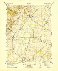
 1944 Hedgesville1944 Print · USGSBerkeley County and the Maryland borderlands are captured here during the mid-forties, showing a landscape defined by the Potomac River and the Chesapeake and Ohio Canal. Genealogists can trace family roots through markers like Oak Grove School or the rural settlements of Hedgesville and Bedington.
 - 1944 Map of Martinsburg
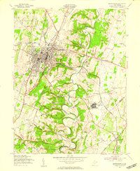
 1944 Martinsburg1944 Print · USGSBerkeley County during the mid-forties reveals a landscape transitioning from traditional farming to wartime industrial and military activity. Researchers can trace family roots through the Dry Run Sunday School, locate the Newton D Baker General Hospital U S Army, and see the rail-side growth of Martinsburg.
 - 1944 Map of Shepherdstown
 1944 Shepherdstown1944 Print · USGSShepherdstown and Sharpsburg sit on opposite banks of the Potomac during the mid-1940s, a landscape defined by the river’s deep meanders and the canal era. Trace the Chesapeake and Ohio Canal (Abandoned) and old rural landmarks like Millers Sawmill or Fairview School.
 - 1944 Map of Middleway
 1944 Middleway1944 Print · USGSJefferson County at the height of the Second World War was a network of rural hamlets and rail lines. Genealogists and historians can trace family-named sites from Lower Johnsontown to Summit Point and the U S Fish Hatchery.
 - 1944 Map of Williamsport
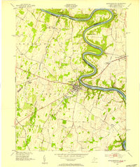
 1944 Williamsport1944 Print · USGSMaryland and West Virginia meet along the Potomac during the mid-1940s, where river-based industry and rail lines converge. Genealogists and historians can trace family-named landmarks like Whitings Neck, local schools like Woburn School, and the path of the Chesapeake and Ohio Canal.2 unique versions available
 - 1944 Map of Williamsport, 1959 Print
 1944 Williamsport1959 Print · USGSMaryland and West Virginia meet along the winding Potomac in the mid-1940s, a landscape defined by river trade and mountain ridges. Genealogists and historians can trace the Chesapeake and Ohio Canal past McCoys Ferry, Cushwa Mill, and the Stonewall Jackson Monument.2 unique versions available
 - 1944 Map of Martinsburg, 1964 Print
 1944 Martinsburg1964 Print · USGSThe West Virginia Panhandle is captured during the mid-1940s, revealing a landscape of vital rail junctions and Potomac River crossings. Genealogists and historians can trace the foundations of Shepherdstown and Martinsburg, alongside landmarks like Martin Chapel and the Newton D Baker General Hospital.
 - 1948 Map of Baltimore
 1948 Baltimore1948 Print · USGSMaryland and Pennsylvania crossroads are captured in the late 1940s, showing a landscape defined by historic rail lines and major military installations. Genealogists can trace family connections in Gettysburg, Westminster, and near the U.S. Naval Academy in Annapolis.2 unique versions available
 - 1948 Map of Cumberland
 1948 Cumberland1948 Print · USGSMid-century Appalachia and the Shenandoah Valley are shown in detail, documenting the industrial and transportation hubs of the tri-state area. Genealogists can trace family roots through settlements like Double Tollgate and Bunker Hill or along the Baltimore & Ohio RR.3 unique versions available
 - 1949 Map of Hedgesville
 1949 Hedgesville1949 Print · USGSThe Potomac River valley in the late 1940s was a hub of canal history and industrial transition. Researchers can trace the path of the Chesapeake and Ohio Canal, locate the Stonewall Jackson Monument, and find vanished infrastructure like Mc Coys Ferry or the Old Mill.
 - 1952 Map of Cumberland
 1952 Cumberland1952 Print · USGSThe Potomac Highlands and the Shenandoah Valley are revealed in this early 1950s survey of the Appalachian interior. Researchers can trace the river-and-rail corridors connecting Cumberland, Winchester, and the recreational waters of Deep Creek Lake.
 - 1953 Map of Williamsport, 1954 Print
 1953 Williamsport1954 Print · USGSMaryland and West Virginia meet along the winding Potomac in the early fifties, capturing a landscape shaped by historical transit. Genealogists can trace family footprints near Williamsport, Downsville, and rural landmarks like Salem Ch or Greenlawn Cem.4 unique versions available
 - 1953 Map of Shepherdstown, 1954 Print
 1953 Shepherdstown1954 Print · USGSThe Potomac River and its dramatic loops at Terrapin Neck define the border between West Virginia and Maryland in the early fifties. Genealogists and local historians can trace landmarks like Shepherd College, Antietam Station, and Marvin Chapel.4 unique versions available
 - 1954 Map of Baltimore
 1954 Baltimore1954 Print · USGSThe Mid-Atlantic region in the early fifties shows a landscape of growing suburban centers and heavy rail corridors. Trace mid-century transit networks and military landmarks from the Aberdeen Proving Ground to the Gettysburg National Military Park.
 - 1955 Map of Martinsburg, 1957 Print
 1955 Martinsburg1957 Print · USGSMid-century Martinsburg serves as a bustling hub of rail transport and medical infrastructure during this post-war period. Genealogists and local historians can trace family locations near Rosedale Cemetery, Eagle Chapel, or the U of W Va Experimental Farm.2 unique versions available
Showing maps 1-25 of 57
Top cities of Berkeley County
Frequently asked questions
- What are the different types of historical maps available for Berkeley County?
- What is the oldest map of Berkeley County?
- Where can I purchase historical maps of Berkeley County for my home or office?
- Where can I download high-res historical maps of Berkeley County?
- Are there historical topographic maps available for Berkeley County?
- Is there historical aerial imagery available for Berkeley County?
- Where are historical maps of Berkeley County sourced from?