1940s Maps of Berkeley County, West Virginia
Explore 13 historic maps of Berkeley County from the 1940s. These maps offer a rare glimpse into what life looked like during the 1940s — showing old roads, neighborhoods, homes, and landmarks that have changed or disappeared over time.
Whether you're researching your family's past, planning a metal detecting trip, or studying how Berkeley County's landscape evolved across the 1940s, these high-resolution maps are a powerful tool for exploring the history of this region.
- Focus on a specific era: All maps on this page are from the 1940s, giving you a focused view of this time period.
- See what’s changed: Compare century-old streets, trails, and buildings to today's modern landscape using overlays and satellite layers.
- Research with precision: Use these maps for genealogy, historical research, land use analysis, or educational projects.
- View, download, or print: Maps are fully viewable online in high resolution, and can be downloaded or printed for your own records.
Start exploring Berkeley County's history through authentic maps from the 1940s. This is your window into the past.
Berkeley County, WV maps
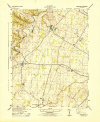
(13)- 1942 Map of Hagerstown
 1942 Hagerstown1942 Print · USGSThe Cumberland Valley and Potomac corridor are captured here at the height of the Second World War rail-and-river era. Genealogists and historians can trace the industrial landscape of Richmond Furnace, the route of the Chesapeake and Ohio Canal, and the grounds of Camp Ritchie.
 - 1943 Map of Gerrardstown
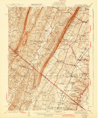 1943 Gerrardstown1943 Print · USGSBerkeley County and the West Virginia-Virginia borderlands are captured here during the mid-1940s as a thriving network of valley settlements and mountain gaps. Researchers can locate family landmarks like the Old Stone Ch, the County Home, and the old Tollgate at Inwood.
 - 1943 Map of Hagerstown
 1943 Hagerstown1943 Print · USGSThe Cumberland Valley was a critical wartime logistics hub in the 1940s, teeming with rail traffic and new military installations. Genealogists and historians can trace the Chesapeake and Ohio Canal or locate local landmarks like Richmond Furnace and Camp Ritchie.
 - 1944 Map of Hedgesville
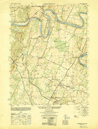
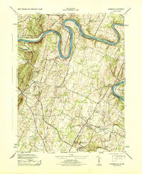 1944 Hedgesville1944 Print · USGSBerkeley County and the Maryland borderlands are captured here during the mid-forties, showing a landscape defined by the Potomac River and the Chesapeake and Ohio Canal. Genealogists can trace family roots through markers like Oak Grove School or the rural settlements of Hedgesville and Bedington.
 - 1944 Map of Martinsburg
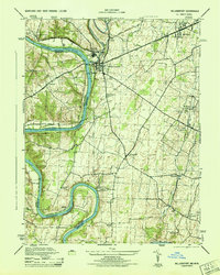
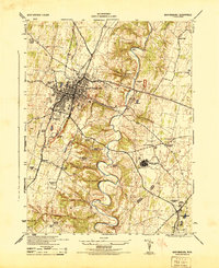 1944 Martinsburg1944 Print · USGSBerkeley County during the mid-forties reveals a landscape transitioning from traditional farming to wartime industrial and military activity. Researchers can trace family roots through the Dry Run Sunday School, locate the Newton D Baker General Hospital U S Army, and see the rail-side growth of Martinsburg.
 - 1944 Map of Shepherdstown
 1944 Shepherdstown1944 Print · USGSShepherdstown and Sharpsburg sit on opposite banks of the Potomac during the mid-1940s, a landscape defined by the river’s deep meanders and the canal era. Trace the Chesapeake and Ohio Canal (Abandoned) and old rural landmarks like Millers Sawmill or Fairview School.
 - 1944 Map of Middleway
 1944 Middleway1944 Print · USGSJefferson County at the height of the Second World War was a network of rural hamlets and rail lines. Genealogists and historians can trace family-named sites from Lower Johnsontown to Summit Point and the U S Fish Hatchery.
 - 1944 Map of Williamsport
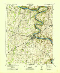
 1944 Williamsport1944 Print · USGSMaryland and West Virginia meet along the Potomac during the mid-1940s, where river-based industry and rail lines converge. Genealogists and historians can trace family-named landmarks like Whitings Neck, local schools like Woburn School, and the path of the Chesapeake and Ohio Canal.2 unique versions available
 - 1944 Map of Williamsport, 1959 Print
 1944 Williamsport1959 Print · USGSMaryland and West Virginia meet along the winding Potomac in the mid-1940s, a landscape defined by river trade and mountain ridges. Genealogists and historians can trace the Chesapeake and Ohio Canal past McCoys Ferry, Cushwa Mill, and the Stonewall Jackson Monument.2 unique versions available
 - 1944 Map of Martinsburg, 1964 Print
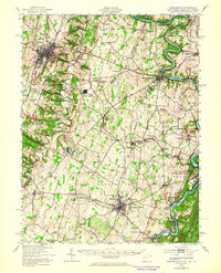 1944 Martinsburg1964 Print · USGSThe West Virginia Panhandle is captured during the mid-1940s, revealing a landscape of vital rail junctions and Potomac River crossings. Genealogists and historians can trace the foundations of Shepherdstown and Martinsburg, alongside landmarks like Martin Chapel and the Newton D Baker General Hospital.
 - 1948 Map of Baltimore
 1948 Baltimore1948 Print · USGSMaryland and Pennsylvania crossroads are captured in the late 1940s, showing a landscape defined by historic rail lines and major military installations. Genealogists can trace family connections in Gettysburg, Westminster, and near the U.S. Naval Academy in Annapolis.2 unique versions available
 - 1948 Map of Cumberland
 1948 Cumberland1948 Print · USGSMid-century Appalachia and the Shenandoah Valley are shown in detail, documenting the industrial and transportation hubs of the tri-state area. Genealogists can trace family roots through settlements like Double Tollgate and Bunker Hill or along the Baltimore & Ohio RR.3 unique versions available
 - 1949 Map of Hedgesville
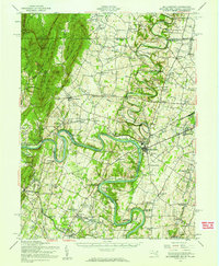
 1949 Hedgesville1949 Print · USGSThe Potomac River valley in the late 1940s was a hub of canal history and industrial transition. Researchers can trace the path of the Chesapeake and Ohio Canal, locate the Stonewall Jackson Monument, and find vanished infrastructure like Mc Coys Ferry or the Old Mill.
End of results
Showing maps 1-13 of 13
Top cities of Berkeley County
Frequently asked questions
- What are the different types of historical maps available for Berkeley County?
- What is the oldest map of Berkeley County?
- Where can I purchase historical maps of Berkeley County for my home or office?
- Where can I download high-res historical maps of Berkeley County?
- Are there historical topographic maps available for Berkeley County?
- Is there historical aerial imagery available for Berkeley County?
- Where are historical maps of Berkeley County sourced from?