1970s Maps of Berkeley County, West Virginia
Explore 6 historic maps of Berkeley County from the 1970s. These maps offer a rare glimpse into what life looked like during the 1970s — showing old roads, neighborhoods, homes, and landmarks that have changed or disappeared over time.
Whether you're researching your family's past, planning a metal detecting trip, or studying how Berkeley County's landscape evolved across the 1970s, these high-resolution maps are a powerful tool for exploring the history of this region.
- Focus on a specific era: All maps on this page are from the 1970s, giving you a focused view of this time period.
- See what’s changed: Compare century-old streets, trails, and buildings to today's modern landscape using overlays and satellite layers.
- Research with precision: Use these maps for genealogy, historical research, land use analysis, or educational projects.
- View, download, or print: Maps are fully viewable online in high resolution, and can be downloaded or printed for your own records.
Start exploring Berkeley County's history through authentic maps from the 1970s. This is your window into the past.
Berkeley County, WV maps
(6)- 1972 Map of Tablers Station, 1974 Print
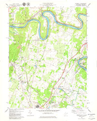
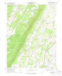 1972 Tablers Station1974 Print · USGSBerkeley County in the early seventies shows a landscape shaped by the ridge of North Mountain and the Penn Central railroad. Researchers can locate rural landmarks such as Pitzers Chapel, Valley View Sch, and the old depot at Tablers Station.2 unique versions available
 - 1978 Map of Middleway, 1979 Print
 1978 Middleway1979 Print · USGSJefferson County in the late seventies remains a landscape of established rail lines and agricultural research. Local historians can trace the paths of the Baltimore and Ohio through Summit Point or locate the historic Harewood estate.2 unique versions available
 - 1978 Map of Shepherdstown, 1979 Print
 1978 Shepherdstown1979 Print · USGSThe Potomac River bends through this 1970s survey of the West Virginia-Maryland border near Shepherdstown. Researchers can trace the grounds of Shepherd College, the Antietam National Battlefield Site, and historic burial grounds like Elmwood Cem.2 unique versions available
 - 1979 Map of Williamsport
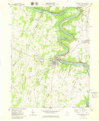
 1979 Williamsport1979 Print · USGSThe Potomac River borderlands in the late seventies reveal a blend of historic canal routes and modern industrial expansion. Genealogists and historians can trace family-named sites like Bnai Abraham Cem, the St James Sch, and the community of Halfway.
 - 1979 Map of Hedgesville
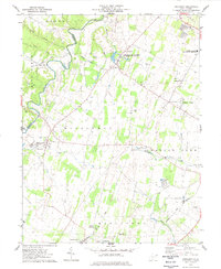
 1979 Hedgesville1979 Print · USGSBerkeley County's northern panhandle and the Maryland border are captured here during the late seventies as industrial rail yards met a landscape of river-side parks. Researchers can find historical landmarks like the Stonewall Jackson Monument, the Old Mill, and the complex lock system of the C & O Canal.
 - 1979 Map of Martinsburg
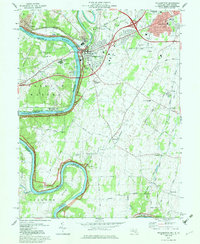
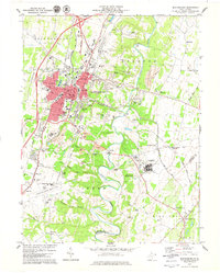 1979 Martinsburg1979 Print · USGSMartinsburg and the Opequon Creek valley are shown here in the late seventies during a period of rapid suburban and industrial growth. Researchers can find well-defined residential neighborhoods, old crossroads like Files Crossroad, and significant landmarks such as the U.S. Veterans Hospital and War Mem Park.
End of results
Showing maps 1-6 of 6
Top cities of Berkeley County
Frequently asked questions
- What are the different types of historical maps available for Berkeley County?
- What is the oldest map of Berkeley County?
- Where can I purchase historical maps of Berkeley County for my home or office?
- Where can I download high-res historical maps of Berkeley County?
- Are there historical topographic maps available for Berkeley County?
- Is there historical aerial imagery available for Berkeley County?
- Where are historical maps of Berkeley County sourced from?