1910s Maps of Braxton County, West Virginia
Explore 6 historic maps of Braxton County from the 1910s. These maps offer a rare glimpse into what life looked like during the 1910s — showing old roads, neighborhoods, homes, and landmarks that have changed or disappeared over time.
Whether you're researching your family's past, planning a metal detecting trip, or studying how Braxton County's landscape evolved across the 1910s, these high-resolution maps are a powerful tool for exploring the history of this region.
- Focus on a specific era: All maps on this page are from the 1910s, giving you a focused view of this time period.
- See what’s changed: Compare century-old streets, trails, and buildings to today's modern landscape using overlays and satellite layers.
- Research with precision: Use these maps for genealogy, historical research, land use analysis, or educational projects.
- View, download, or print: Maps are fully viewable online in high resolution, and can be downloaded or printed for your own records.
Start exploring Braxton County's history through authentic maps from the 1910s. This is your window into the past.
Braxton County, WV maps
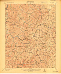
(6)- 1910 Map of Sutton Special
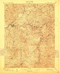 1910 Sutton Special1910 Print · USGSCentral West Virginia at the end of the first decade of the 1900s shows a landscape transformed by river-valley railroads. Genealogists can trace family roots through hillside settlements like Flatwoods and Centralia or locate early post offices at Gillespie Hyer PO and Bakers Run Levi PO.3 unique versions available
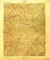
 - 1910 Map of Gassaway
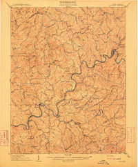 1910 Gassaway1910 Print · USGSBraxton County at the peak of its rail-and-river era is captured here, centered on the growing industrial hub of Gassaway. Genealogists and historians can trace early post offices and settlements like Villa Nova Duck PO, Strange Creek, and the Coal and Coke Ry corridor.3 unique versions available
 - 1912 Map of Crawford
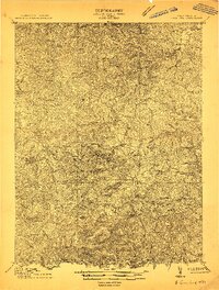 1912 Crawford1912 Print · USGSUpshur County’s rugged interior is captured here in the early twentieth century, showing a landscape shaped by narrow river valleys and high ridges. Genealogists can trace a remarkable network of country schoolhouses like Jewel School and early post offices at Rock Cave PO and Frenchton.2 unique versions available
 - 1913 Map of Hacker Valley
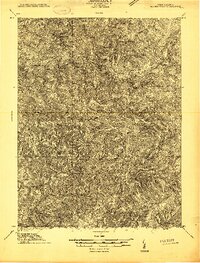 1913 Hacker Valley1913 Print · USGSWest Virginia's high-country settlements come to life in this early twentieth-century survey of the rugged Elk River headwaters. Researchers can trace the original locations of rural landmarks like Buckwheat Church, Windy Gap School, and the remote Salt Lick Settlement.2 unique versions available
 - 1914 Map of Crawford
 1914 Crawford1914 Print · USGSUpshur and Lewis Counties are shown here just before the First World War, when remote mountain hollows were filled with small schoolhouses and family farms. Trace early rail travel at Roanville Sta or locate family roots near Alkires Mills and the Handkerchief Union School.3 unique versions available
 - 1915 Map of Hacker Valley
 1915 Hacker Valley1915 Print · USGSThe high ridges of Webster and Lewis counties are captured here in the years before the Great War, showing a landscape of isolated mountain settlements and rail-driven timber hubs. Genealogists can trace family footprints at Salisbury Sta Removal PO, Cleveland, and nearly a dozen rural schoolhouses like Snuffville School.4 unique versions available
End of results
Showing maps 1-6 of 6
Top cities of Braxton County
Frequently asked questions
- What are the different types of historical maps available for Braxton County?
- What is the oldest map of Braxton County?
- Where can I purchase historical maps of Braxton County for my home or office?
- Where can I download high-res historical maps of Braxton County?
- Are there historical topographic maps available for Braxton County?
- Is there historical aerial imagery available for Braxton County?
- Where are historical maps of Braxton County sourced from?