
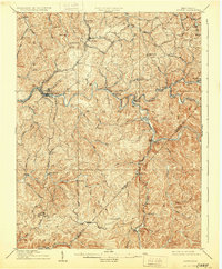
1910 Map of Sutton Special
USGS Topo · Published 1910About this map
Sutton sits as a central hub along the winding Elk River, serving as the gateway to a landscape defined by deep river valleys and the early expansion of the timber and coal industries. This 1908 survey, published in 1910, illustrates the intricate transport network of central West Virginia, where the Coal and Coke Ry and the Baltimore and Ohio RR follow the contours of the waterways to reach isolated settlements. Notable rural post offices such as Gillespie Hyer PO and Bakers Run Levi PO emphasize the era's reliance on river-bottom communities for commerce and communication. The map captures the rugged interior before modern highway development, highlighting the significance of the Holly River and the Birch River in shaping the early 20th-century geography of Braxton and Webster counties.
Find a feature on this map
71 named features on this map. Tap any name to fly to it.
Don’t see what you’re looking for? This feature index may not catch every label — zoom into the map to look around manually.
Map Details
Editions of this 1910 Sutton Special Map
3 editions found
Other maps of this area

1889 · Nicholas
USGS Topo · 1:125,000

1891 · Nicholas
USGS Topo · 1:125,000

1891 · Huntersville
USGS Topo · 1:125,000

1893 · Buckhannon
USGS Topo · 1:125,000

1893 · Sutton
USGS Topo · 1:125,000

1894 · Huntersville
USGS Topo · 1:125,000

1896 · Buckhannon
USGS Topo · 1:125,000

1897 · Buckhannon
USGS Topo · 1:125,000

1901 · Nicholas
USGS Topo · 1:125,000

1906 · Glenville
USGS Topo · 1:62,500