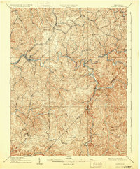
1910 Map of Sutton
USGS Topo · Published 1928About this map
The Elk River winds through the heart of Braxton County, anchoring a landscape defined by deep-cut valleys and the early industrial expansion of central West Virginia. Sutton serves as the primary hub along the river, where the Coal and Coke Ry follows the water's edge to connect timber and coal interests. The intricate network of tributary runs, such as Old Woman Run and Buffalo Creek, reveals a pattern of dispersed ridge-and-hollow settlements that were typical of the era. To the south and east, the Ohio River and Charleston RR snakes through narrow corridors to reach communities like Centralia and Erbacon on the Nicholas County border. The presence of several post offices, including Gillespie Hyer PO and Bakers Run Levi PO, underscores the vital importance of these small rail-stops in maintaining communication across the remote terrain of the Holly and Hamilton districts.
Find a feature on this map
76 named features on this map. Tap any name to fly to it.
Don’t see what you’re looking for? This feature index may not catch every label — zoom into the map to look around manually.
Map Details
Editions of this 1910 Sutton Map
3 editions found

Other maps of this area

1889 · Nicholas
USGS Topo · 1:125,000

1891 · Nicholas
USGS Topo · 1:125,000

1891 · Huntersville
USGS Topo · 1:125,000

1893 · Buckhannon
USGS Topo · 1:125,000

1893 · Sutton
USGS Topo · 1:125,000

1894 · Huntersville
USGS Topo · 1:125,000

1896 · Buckhannon
USGS Topo · 1:125,000

1897 · Buckhannon
USGS Topo · 1:125,000

1901 · Nicholas
USGS Topo · 1:125,000

1906 · Glenville
USGS Topo · 1:62,500