
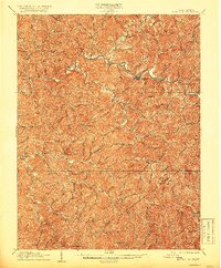
1906 Map of Glenville
USGS Topo · Published 1906About this map
The Little Kanawha River meanders through this early-century West Virginia landscape, anchoring the regional hub of Glenville at its center. This survey, directed by Charles D. Walcott, illustrates a rural economy defined by deep valleys and the intricate drainage basins of Tanner Creek and Cedar Creek. The settlement pattern follows these watercourses, with small post offices and crossroads like Dekalb, Stumptown, and Sand Fork serving as isolated focal points for the surrounding hills.
Find a feature on this map
108 named features on this map. Tap any name to fly to it.
Don’t see what you’re looking for? This feature index may not catch every label — zoom into the map to look around manually.
Map Details
Editions of this 1906 Glenville Map
2 editions found
Other maps of this area

1893 · Sutton
USGS Topo · 1:125,000

1904 · Vadis
USGS Topo · 1:62,500

1906 · Holbrook
USGS Topo · 1:62,500

1906 · Burnsville
USGS Topo · 1:62,500

1906 · Otter
USGS Topo · 1:62,500

1907 · Otter
USGS Topo · 1:62,500

1907 · Harrisville
USGS Topo · 1:62,500

1907 · Arnoldsburg
USGS Topo · 1:62,500

1908 · Gassaway
USGS Topo · 1:48,000

1908 · Sutton
USGS Topo · 1:48,000