
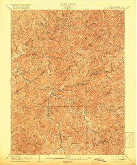
1906 Map of Burnsville
USGS Topo · Published 1906About this map
Burnsville sits at the heart of this central West Virginia landscape, where the Kanawha and Burnsville river systems carve through steep terrain. At the turn of the century, the region was defined by a dense network of small mountain settlements and post offices such as Kemper PO Bennett and Confluence PO Orlando. The mapping captures a period of intense rural activity, evidenced by numerous mills like Bealls Mills, Stouts Mills, and Falls Mill, which served as local economic hubs along the many forks and runs. The distribution of family-named landmarks like Finster and Aspinall reflects the deep-rooted genealogical history of the Gilmer, Braxton, and Lewis county borderlands. Higher elevations like Pine Knob and Rush Knob overlook a landscape where life followed the winding paths of Oil Creek and Little Kanawha.
Find a feature on this map
126 named features on this map. Tap any name to fly to it.
Don’t see what you’re looking for? This feature index may not catch every label — zoom into the map to look around manually.
Map Details
Editions of this 1906 Burnsville Map
2 editions found
Other maps of this area

1893 · Buckhannon
USGS Topo · 1:125,000

1893 · Sutton
USGS Topo · 1:125,000

1896 · Buckhannon
USGS Topo · 1:125,000

1897 · Buckhannon
USGS Topo · 1:125,000

1904 · Weston
USGS Topo · 1:62,500

1904 · Vadis
USGS Topo · 1:62,500

1906 · Holbrook
USGS Topo · 1:62,500

1906 · Glenville
USGS Topo · 1:62,500

1908 · Gassaway
USGS Topo · 1:48,000

1908 · Sutton
USGS Topo · 1:48,000