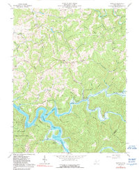
1967 Map of Newville
USGS Topo · Published 1989About this map
Sutton Lake dominates the central landscape of this West Virginia interior, where the Holly River and Elk River converge within the U S Reservation Boundary. The topography is defined by prominent ridges such as Keener Ridge and Harper Ridge, which separate the numerous hollows and runs that feed into the main river systems. Small communities and family settlements are scattered throughout the hills, including Newville, Corley, and Marpleton, often centered around local landmarks like the Mt Hebron Ch or the High Knob Sch & Ch.
Find a feature on this map
72 named features on this map. Tap any name to fly to it.
Don’t see what you’re looking for? This feature index may not catch every label — zoom into the map to look around manually.
Map Details
Editions of this 1967 Newville Map
3 editions found
Other maps of this area

1893 · Buckhannon
USGS Topo · 1:125,000

1893 · Sutton
USGS Topo · 1:125,000

1896 · Buckhannon
USGS Topo · 1:125,000

1897 · Buckhannon
USGS Topo · 1:125,000

1906 · Burnsville
USGS Topo · 1:62,500

1908 · Sutton
USGS Topo · 1:48,000

1910 · Sutton Special
USGS Topo · 1:62,500

1912 · Crawford
USGS Topo · 1:48,000

1913 · Hacker Valley
USGS Topo · 1:48,000

1914 · Crawford
USGS Topo · 1:62,500