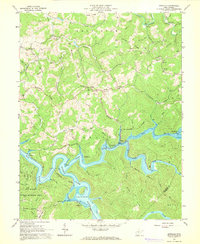
1967 Map of Newville
USGS Topo · Published 1968About this map
Sutton Lake dominates the southern landscape of this 1967 survey, where the Elk River is pooled behind the dam. The map documents a rugged West Virginia terrain defined by narrow ridges like Keener Ridge and Harper Ridge that separate the drainage of the Little Kanawha River to the north from the Holly and Elk watersheds to the south. Small rural communities such as Newville and Palmer are connected by the winding tracks of the Baltimore and Ohio railroad, which follows the river's path through the deep valley.
Find a feature on this map
83 named features on this map. Tap any name to fly to it.
Don’t see what you’re looking for? This feature index may not catch every label — zoom into the map to look around manually.
Map Details
Editions of this 1967 Newville Map
3 editions found
Other maps of this area

1893 · Buckhannon
USGS Topo · 1:125,000

1893 · Sutton
USGS Topo · 1:125,000

1896 · Buckhannon
USGS Topo · 1:125,000

1897 · Buckhannon
USGS Topo · 1:125,000

1906 · Burnsville
USGS Topo · 1:62,500

1908 · Sutton
USGS Topo · 1:48,000

1910 · Sutton Special
USGS Topo · 1:62,500

1912 · Crawford
USGS Topo · 1:48,000

1913 · Hacker Valley
USGS Topo · 1:48,000

1914 · Crawford
USGS Topo · 1:62,500